
Most of us think of volcanoes as these conical peaks that shoot fire from their tops, or gigantic cauldrons of molten lava, but there are some extreme oddball volcanoes out there that I thought would be fun to take a look at given that there is no really new news out of El Hierro (Canary Islands), and the only really new eruption this week (Tungurahua) has been well-covered on the Internet.
While most volcanoes are content to erupt basalt, rhyolite, or tephra ash, there are some volcanoes that are not at all what you think of when thinking of a volcano. Today I'll cover three of these oddball volcanoes, and provide some cool pictures. I picked these as the top three I find to be most intriguing and out of character, and we'll start from the "least weird", although they are all unique in their own way.
#3) Dallol - African Rift Valley, Northern Ethiopia
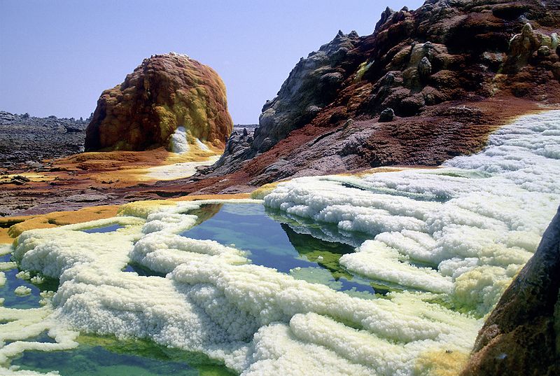
Dallol is one of the strangest sites to see in the world. Formed north of the famed Erta Ale during an eruption in 1926, it is part of the African Rift Valley and has produced one of the world's oddest volcanoes. After its phreatic eruption in 1926, its depth (45m below sea level) has created a landscape not completely unlike the geysers and geothermal activity at Yellowstone. However, the landscape is so alien compared to Yellowstone, being that the geysers, pools, and solfataras spread continuously throughout the volcanic maar.
Dallol is currently being studied by scientists who search for "extremeophiles", or organisms that exist in extreme environments like volcanic vents, acid pools, and extreme temperature. In fact, Dallol is being used by not only biologists, but NASA scientists to determine the scope of how life can exist on other worlds. Scientists now theorize that life on this planet likely sprung up from volcanoes (or similar chemical/heat processes) like Dallol, especially under the ocean at great depths. This is the lowest known land volcano in the African Rift Valley.
Below photo of some geysers at Dallol (Wikipedia).

#2) The Mud Volcano in Indonesia
On the Island of East Java in Indonesia, to the SSE of Ketegan, sits humanity's only known man-made volcano. Referred to as Sidoarjo mud flow or the Lapindo mud. It was born on May 2006, when a natural gas company experienced a blow out on a piece of equipment that resulted in the release of extreme amounts of underground pressure (The gas company has tried to repeatedly claim that this was actually caused by a distant earthquake, but most scientists consider the case closed as to what caused this).
The erupting mud has buried a local down, polluted water, and gives of a sulfuric smell for miles. The mud has become a huge nuisance to the local population, who have cordoned off the mud and directed it towards the Kali Porong river just to the South. The river mouth (which exits to the ocean) is a few miles from the outlet, which quickly gets rid of the muddy sediment and deposits it to the ocean.
You can read more about the Indonesia Mudflow at Wikipedia here.
#1) Ol Doinyo Lengai - African Rift Vally
Perhaps the strangest volcano is Ol Doinyo Lengai in the African Rift Valley. It erupts the most unique and rarest type of lava, carbonatite, and its eruptions are a bit bizarre to behold. Erupting small seeps of lava from flat plateaus at the summit, and producing bizarre spires of spattered carbonatite, this volcano behaves literally like none other. It is a stratovolcano and does produce pyroclastic flows, but rarely does it erupt with violent force. In fact, scientists routinely head to the summit to observe this oddball volcano seep its bizarre lavas onto the crater floors, and observe the creation of its famed spatter monoliths.
A good example of what I'm talking about can be seen below:

Note the grayish color of the lavas, and the small spires that are created when this volcano 'erupts'. This truly is a strange landscape!
Hope you enjoyed hearing about these three oddballs.
While most volcanoes are content to erupt basalt, rhyolite, or tephra ash, there are some volcanoes that are not at all what you think of when thinking of a volcano. Today I'll cover three of these oddball volcanoes, and provide some cool pictures. I picked these as the top three I find to be most intriguing and out of character, and we'll start from the "least weird", although they are all unique in their own way.
Dallol is one of the strangest sites to see in the world. Formed north of the famed Erta Ale during an eruption in 1926, it is part of the African Rift Valley and has produced one of the world's oddest volcanoes. After its phreatic eruption in 1926, its depth (45m below sea level) has created a landscape not completely unlike the geysers and geothermal activity at Yellowstone. However, the landscape is so alien compared to Yellowstone, being that the geysers, pools, and solfataras spread continuously throughout the volcanic maar.
Dallol is currently being studied by scientists who search for "extremeophiles", or organisms that exist in extreme environments like volcanic vents, acid pools, and extreme temperature. In fact, Dallol is being used by not only biologists, but NASA scientists to determine the scope of how life can exist on other worlds. Scientists now theorize that life on this planet likely sprung up from volcanoes (or similar chemical/heat processes) like Dallol, especially under the ocean at great depths. This is the lowest known land volcano in the African Rift Valley.
Below photo of some geysers at Dallol (Wikipedia).
#2) The Mud Volcano in Indonesia
On the Island of East Java in Indonesia, to the SSE of Ketegan, sits humanity's only known man-made volcano. Referred to as Sidoarjo mud flow or the Lapindo mud. It was born on May 2006, when a natural gas company experienced a blow out on a piece of equipment that resulted in the release of extreme amounts of underground pressure (The gas company has tried to repeatedly claim that this was actually caused by a distant earthquake, but most scientists consider the case closed as to what caused this).
The erupting mud has buried a local down, polluted water, and gives of a sulfuric smell for miles. The mud has become a huge nuisance to the local population, who have cordoned off the mud and directed it towards the Kali Porong river just to the South. The river mouth (which exits to the ocean) is a few miles from the outlet, which quickly gets rid of the muddy sediment and deposits it to the ocean.
You can read more about the Indonesia Mudflow at Wikipedia here.
#1) Ol Doinyo Lengai - African Rift Vally
Perhaps the strangest volcano is Ol Doinyo Lengai in the African Rift Valley. It erupts the most unique and rarest type of lava, carbonatite, and its eruptions are a bit bizarre to behold. Erupting small seeps of lava from flat plateaus at the summit, and producing bizarre spires of spattered carbonatite, this volcano behaves literally like none other. It is a stratovolcano and does produce pyroclastic flows, but rarely does it erupt with violent force. In fact, scientists routinely head to the summit to observe this oddball volcano seep its bizarre lavas onto the crater floors, and observe the creation of its famed spatter monoliths.
A good example of what I'm talking about can be seen below:

Note the grayish color of the lavas, and the small spires that are created when this volcano 'erupts'. This truly is a strange landscape!
Hope you enjoyed hearing about these three oddballs.


