In the Afar region of Ethiopia, a large rifting and seismic event has been ongoing now for several weeks. Earthquakes ranging up to magnitude 5.4, with thousands of smaller quakes have been detected in the region between the Fentale and Dofen volcanic systems in the Awash Basin.
INSAR images have revealed a series of dikes, with the central dike being some 44km or longer in length. In the meantime on the ground, there are videos and reports of mud volcanoes spewing hot mud and gasses, creating new 'moats' around the region. Satellite images have also recorded a progressively larger heat and gas anomaly within the crater of Fentale.
The system exists in an are of Africa which is rifting to eventually split off from the main continent. The system constantly spreads apart over the years, resulting in earthquakes and volcanic eruptions when magma rises to fill the gaps left by the tectonic spreading.
It is unclear whether this activity, which as of this writing has diminished to one or two larger quakes per week, down from dozens, will result in a volcanic eruption. However this scenario can't be ruled out, and a reduction in large quakes isn't necessarily a good thing. Also to be considered is that large quakes in the region aren't detected by local instruments. International USGS sensors pick up, generally speaking, any quake around 4.3 and above, so it is likely many smaller quakes are not felt, and not recorded by any local instrumentation.
In Iceland's Reykjanes peninsula, the unrest Northeast of Grindavik was preceded by months of large quakes, which diminished greatly before the eventual eruptions at the Sundhnukagigar fissure series. This was interpreted in Iceland as meaning that the crust was weakened by the large quakes, thus the magma had an easier path to the surface, creating smaller quakes, before the eruptive episodes. Each successive eruptive episode thereafter (continuing now for several years) has been preceded by less and less volcano-tectonic activity before an eruption. Currently, the system is inflated at an eruptible level, however it has not displayed any large quake activity, and the last several eruptions occurred with swarms of less than mag 2.0 before erupting.
So the crisis in Ethiopia is likely not over yet. It could be weeks or months before an eruption, but an eruption cannot be ruled out. It is likely that the dike intrusion has slowed, but this could only mean that the intrusion is finding ways to expand laterally rather than horizontally while it adjusts to the new room underneath the crust that it freed up. It is likely that inflation may resume or result in an eruption at any time, given the sheer size of the intrusion.
It is also possible that the crisis slowly ends without an eruption and simply results in the surficial changes that have already occurred becoming more permanent. Due to the lack of on-the-ground coverage and observations, almost all of this is speculative, at best. But it is an educated speculation that what is now happening in Iceland is a small analog for the large thing that is happening in Ethiopia.

A blog dedicated to publishing new and interesting events regarding our active Earth. Topics include volcanoes, earthquakes, tsunamis, and other seismic events. RSS Feed now available: http://feeds.feedburner.com/VolcanoScienceAndNewsBlog
Wednesday, February 5, 2025
Ethiopia Experiences Massive Dike Intrusion


Wednesday, December 6, 2023
Unrest in Iceland As Reykjanes Enters New Era
REYJANES - ICELAND
The recent unrest at Iceland's Reykjanes Peninsula has generated a lot of media attention, not to mention increasing the stress levels of those unfortunate enough to be on the receiving end of the unrest in Grindavik. Grindavik was evacuated following the events of November 10th, 2023, where a series of extremely strong quakes coupled with a rifting and dike emplacement event left the town with large fissure cracks running in a NE/SW direction, damaging roads, infrastructure, water and power services. Many apartments and homes are now uninhabitable and will need to be rebuilt.
The fissure/rift is estimated to be some 15km/9mi long, and several meters wide.
This was initially thought to be the beginnings of an imminent eruption, however that has not come to pass. Instead, the fissure magma supply appears to have slowed or been cut off, which will likely result in solidification of the dike, at least pertially.
Inflation at the Svartsgeni Power Plant area, which was responsible for the current series of events after accumulated magma found its way into the current dike, now continues at an accelerated pace. Magma intrusion below Svartsgeni is espimated to contribute to an averge land rise of 1 cm per day. At this rate, it is only a matter of time until the inflation reaches the level of the Nov 10th event.
If the inflation does reach this
it is probable that if the status quo continues, and eruption may present to the West of the Svartsgeni power plant, or perhaps migrate further to the East into the previously formed dike. It is impossible to know at this time.
The Reykjanes peninsula (of which the Icelandic capital of Reykjavik is situated on the NE portion), is now entering into an assumed 'Volcanic Dynasty' which may last several hundred years, according to experts. The last cycle of volcanism on the peninsula ended around 1200 AD, after the settlement of Iceland (some eruptions are reported in ancient Icelandic historical sagas/records) after a long period of unrest.
Volcanologists appear certain that this occurs in regular phases on the peninsula, driven by the rifting between the North American plate, and the Eurasian plate. The two plates are moving away from each other at around the rate that human fingernails grow per year. This eventually results in the creation of cracks through which the mantle plume under Iceland can inject magma to fill the gaps. This is what is thought to be occurring now underneath the peninsula.
If the current sequence of events does result in an eruption, it will likely happen near the end of December or the first couple weeks of January. However this is not a certainty as volcanoes don't always behave how we expect them to, there are simply too many variables.
In the event that a major or minor eruption does happen around the Svartsgeni power plant, or the nearby town of Grindavik, this will plunge the peninsula and the capitol into a new era of turbulence for the island nation. Residents that may be forced to locate will need to go *somewhere* and permanent solutions for housing will likely be needed - similar to the recent destruction in Hawaii's 2018 eruptions, and the 2023 loss of Lahaina, Maui, to fires (not volcano related).
In Hawaii, it has been several months since the Lahaina disaster, and a little over 5 years since the Kilauea East Rift Zone eruption that resulted in the loss of over 700 homes, displacing thousands of residents.
Iceland's situation is being closely monitored.
Friday, December 9, 2022
Mauna Loa Erupts - Eruption Now Waning
HAWAII
Mauna Loa, dormant since its last eruption in 1984, and after a very long inflation period with starts, stops, and starts, entered into an eruptive phase Nov 30th (HST) with a visually spectacular eruption. The eruption began with a fissure eruption at the summit of Moku'āweoweo caldera at just around midnight.


Given the long dormancy period, I suspect this was 'the opening act' for this volcano, and we can expect more frequent eruptions in the near future, as the structure of the mountain has surely been altered by the recent activity, meaning that cracks and fractures may allow for other lavas to erupt.
You can keep up to date with Mauna Loa at the Hawaiian Volcano Observatory on the USGS site.
Wednesday, September 29, 2021
Kilauea Erupts, La Palma Eruption Intensifies, Fagradalsfjall Quakes Raise Questions
HAWAII, USA - Kilauea began a new eruption after weeks and months of inflationary tilt and occasional quake swarms. As of 3:20PM HST, USGS posted the following update:
"Kīlauea volcano is erupting. At approximately 3:20 p.m. HST on September 29, 2021, the USGS Hawaiian Volcano Observatory (HVO) detected glow in Kīlauea summit webcam images indicating that an eruption has commenced within Halemaʻumaʻu crater in Kīlauea’s summit caldera, within Hawai‘i Volcanoes National Park. Webcam imagery shows fissures at the base of Halemaʻumaʻu crater generating lava flows on the surface of the lava lake that was active until May 2021.
The US Geological Survey Hawaiian Volcano Observatory (HVO) is elevating Kīlauea’s volcano alert level to from WATCH to WARNING and its aviation color code from ORANGE to RED as this new eruption and associated hazards are evaluated. The activity is confined to Halemaʻumaʻu and the hazards will be reassessed as the eruption progresses.
USGS volcano alert levels and aviation color codes are explained here: https://www.usgs.gov/natural-hazards/volcano-hazards/about-alert-levels
The opening phases of eruptions are dynamic and uncertain. HVO continues to monitor the volcano closely and will report any significant changes in future notices. Stay informed about Kīlauea by following volcano updates and tracking current monitoring data on the HVO web page (https://www.usgs.gov/volcanoes/kilauea/volcano-updates) or by signing up to receive updates by email at this site: https://volcanoes.usgs.gov/vns2/.
HVO is in constant communication with Hawai‘i Volcanoes National Park as this situation evolves. The eruption is currently taking place entirely within the closed area of Hawai‘i Volcanoes National Park.
Hazard Analysis: This new eruption at Kīlauea’s summit is occurring within a closed area of Hawai'i Volcanoes National Park. Therefore, high levels of volcanic gas are the primary hazard of concern, as this hazard can have far-reaching effects down-wind. Large amounts of volcanic gas—primarily water vapor (H2O), carbon dioxide (CO2), and sulfur dioxide (SO2)—are continuously released during eruptions of Kīlauea Volcano. As SO2 is released from the summit, it will react in the atmosphere to create the visible haze known as vog (volcanic smog) that has been observed downwind of Kīlauea. Vog creates the potential for airborne health hazards to residents and visitors, damages agricultural crops and other plants, and affects livestock. For more information on gas hazards at the summit of Kīlauea, please see: https://pubs.er.usgs.gov/publication/fs20173017.
Vog information can be found at https://vog.ivhhn.org/.
Additional hazards include Pele's hair and other lightweight volcanic glass fragments from the lava fountains that will fall downwind of the fissure vents and dust the ground within a few hundred meters (yards) of the vent (s). Strong winds may waft lighter particles to greater distances. Residents should minimize exposure to these volcanic particles, which can cause skin and eye irritation.
Other significant hazards also remain around Kīlauea caldera from Halemaʻumaʻu crater wall instability, ground cracking, and rockfalls that can be enhanced by earthquakes within the area closed to the public. This underscores the extremely hazardous nature of Kīlauea caldera rim surrounding Halemaʻumaʻu crater, an area that has been closed to the public since late 2007."
The eruption is occurring within the summit lava lake which was recently formed in December 2020, when a small fissure poured into the water lake which had accumulated after the caldera forming collapse of 2018.
The lava appears to have had no trouble in breaking through the still-cooling lava lake to 'reactivate' it, and is currently filling the caldera with newly erupted lava. This appears at this time to be a different fissure, perhaps related to a magma intrusion that occurred several weeks earlier.


Quakes at Hekla, which are uncommon but can preceded eruptions, have been ongoing for quite a while, and scientists say that it is more pressurized than it was during its last large eruption.
And surprisingly, there is even some geological action out in the Snaefellsnes Peninsula, where the volcanic system of Ljosufjoll is displaying seismic activity as well. The last eruption in this region was some 1000 years ago.
Wednesday, September 15, 2021
Eruption at Fagradalsfjall Continues After Lull
In Iceland, on the Reykjanes peninsula, the eruption at Fagradalsfjall entered into a 9 day dormancy, which caused some to speculate that the eruption may be ending. This was proven false several days ago, when rock fracture volcanic quakes, and a gradual increase in tremor resulted in a new phase in the eruption. Currently the volcano is 'pulsing' with activity that ranges from 10-15 minutes of lava effusion, and about another 15-20 minutes of quiet. This pattern has continued for several days now.
Today, a large lava breakout near the main erupting crater created a cascade of lava down into Natthagi valley (translated to 'Nigeria Valley' with online translation).

The current view from Nigeria Valley. Courtesy of mbl.is.
Earlier, cameras trained on the volcanic crater also captured an individual scaling, then walking along the crater rim of the main vent, which was, to say the least, extremely foolish and a poor example for others. Icelandic authorities have had to repeatedly warn people not to tread on recently cooled magma both in Nigeria valley, but at Geldingadalur valley.
Months earlier, one man, who later identified himself on social media, was spotted near the main crater narrowly escaping a sudden lava gush.
People should be reminded this volcano is unpredictable, and has shown to be hazardous in many ways. Gases that may seem to be blowing away from you could swiftly shift direction. Lapilli in the air can cause lung irritation. Lava breakouts, and new fissures are still possible. The very ground could open without warning, and issue hot gases and lava. Volcanoes are not toys, and they're not good for the 'Gram if you're dead.
End PSA.
Tremor plots currently show a high level of activity, and it is unknown whether the tremor plots currently being displayed are the result of a computer glitch, or if they are truly what is occuring.


But please, for all that is sane and good in this world - DO NOT STEP ON THE LAVA.
Monday, July 5, 2021
Why The Eruption At Fagradalsfjall Is Unprecedented
The eruption that began in Iceland's Reykjanes peninsula in March of 2021 has for the most part shocked scientists, volcano enthusiasts, and tourists alike. The volcano, it seemed at the time, was (or still is, depending on who you ask) part of the Krýsuvík-Trölladyngja system, which was experiencing its first magmatic eruption in some 800 years. The conventional wisdom at the time was that this was a relatively small eruption that would probably only last a few weeks. This has been proven wrong, the question now is why?
One need not look much farther than Iceland itself. Icelandia is a submerged continent who's geological history is incredibly complex. Until recently, Iceland was thought to be a volcanic hotspot underneath an oceanic spreading ridge. It turns out, that not only is Icelandia a continent, it may have existed since before the ridge, been submerged, only to split and have a hotspot form under it in the last several million years.
This is significant, since original, ancient continental crust would provide more protection/insulation from magmatic intrusion, but since the continent of Icelandia drifted into (or was split in two by) an oceanic rift, the geology is unique. On one hand you have very thick crustal regions, and in the split middle, you have a thin layer of hardened material before you reach a mantle source, in some areas.
This explains in part the presence of stratovolcanoes on Iceland, as typically a stratovolcano is constructed by means of recycled or at least conglomerate material - mantle sourced, primitive magmas, mixing with more advanced, modern crustal material, which incorporates both H2O and organic components leading to explosive, tephra generating eruptions.
Without any crustal 'recycling', you'd expect the entirety of Iceland, or at least most of it, to display mostly Hawaiian-style hotspot eruptions much like the current eruption at Geldingadalur.
Back to Iceland's newest eruption, it has not gone according to conventional science, however there is precedent.
A few days ago, Fagradalsfjall volcano had a brief period where ash was emitted, in what was thought at the time to be the end of the eruption. A similar event occurred at Kilauea, on the big island of Hawaii, at Pu'u'O'o crater. Magma had drained down rift, rapidly draining the small magma chamber under the spatter cone of Pu'u'O'o, and quickly, the roof of the chamber caved in, generating a rather interesting plume of ash, gas, and vapor. While magma has not yet returned to Pu'u'O'o, it can be reasonably assumed that it may, given the right circumstances.
Fagradalsfjall, however, is brand new! This is a magma dyke that has come from quite a depth, far deeper than any extant magma chamber in Iceland. It is not a magma chamber, rather it is a crack that goes down far enough to a mantle source, to build a magma chamber ABOVE land. It is building a new shield volcano. A Shield volcano forms layer-by-layer. The most famous example of which is probably Mauna Loa, the largest active volcano by volume in the world, on the big island of Hawaii.
Mauna Loa likely started life out just as Fagradalsfjall, as a minor crack in the ground, slowly growing and expanding, issuing fluid lavas, until a massive, shield-shaped mountain formed. Over millions of years, volcanoes like Mauna Loa grow their profile, building their own reservoirs of magma, and over time, building their own magmatic plumbing systems. The older they get, the less likely magma injections lead to eruptions (at least for most non-hotspot shields).
Hotspot shield volcanoes, like Mauna Loa, however, can grow to immense proportions, and last for millions of years. While it is highly unlikely that the new volcano at Fagradalsfjall will be as dynastic as Mauna Loa, it is far, far too soon to tell.
What is clear, and what I will predict is that Fagradalsfjall (or whatever the official name for it will be in the future) is likely to be a very long eruption, with minor pauses, sometimes even months, in between. But this volcano is likely here to stay, providing Iceland with a bit of tourism excitement, but also questions in regards to how ti handles the eruption and disruption to infrastructure.
Already, Iceland has fought this volcano. It has constructed several dirt and rock berms by which to redirect the lava flows away from roads, homes and infrastructure. While the first two berms constructed did fail, several others appear to have learned from the previous berms, and have held. One is preventing the lava from spilling into a valley to the SW of the main vent, while the other is preventing lava from advancing towards the South Road highway, and several farm houses.
Whether this is going to work or not is unclear, but one thing is certainly notable - Iceland is the only country that I am aware of to successfully fight and redirect lava flows when they threated critical infrastructure. This is quite an impressive feat, and civil engineers should take note.
Today's activity at Fagrdalsfjall seems to consist mostly of lava-lake activity within the main vent, with some occasional overflows and large strombolian explosions. A new pattern has emerged in the past several days, from an easy-effusiveness to violent lava lake activity, followed by periods of outflow, then massive overflows. This is then typically followed by a period of perceived inactivity (although we cannot tell what is going on under the crater, it is assumed that 70% of the eruption and effusion is occurring out of view in underground lava tubes).
The resumption of activity is typically begun by gas emissions, followed by the gradual appearance of lava fountaining, and eventual resumption of overflows. The time is not consistent between events, so it is unclear whether this is just a random 'sputter' or if the volcano is building up to something else, or building to an end. I suspect this will keep going on for several years, if not decades. But only time will tell.
Monday, April 5, 2021
Second Fissure Opens Up At Fagradalsfjall (UPDATE - THIRD FISSURE ERUPTS)
REYKJANES PENINSULA, ICELAND - An approximately 200 meter long fissure has opened up to the SW of the first eruptive vents at Fagradalsfjall at approximately noon Iceland time on April 5th. The fissure opened up some 200 meters from a rescue and aid camp that was set up nearby, which was quickly dismantled and moved.

The new fissure can be seen below in relation to the main vent, with lave spilling down a valley to the ENE.


Maradali valley, like Geldingadaulur, is not close to any human settlements and lava is not expected to affect any structures or infrastructure at this time.


UPDATE 2:
The lava from the new fissure vent is rapidly approaching Geldingadaulur and is about to enter the valley. The vent opened quite close to Geldingadaulur.


Friday, March 19, 2021
ERUPTION In Iceland! Fagradalsfjall ERUPTS
About 1 hour ago, Mount Fagradalsfjall erupted. Some webcams are able to see the eruption including this one. Color video (not the best shot) can be seen here. A camera from RUV.is is here.

A massive glow can be seen above the mountain, in the area that was predicted to be the most likely spot for an eruption to occur.


Wednesday, February 24, 2021
Iceland Has Major Quake Swarm At Reykjanes Peninsula [UPDATED]
Reykjanes, Iceland is experiencing another major quake swarm, with the largest quake so far at magnitude 5.7. The swarm is in the same general area as previous seismicity within recent years, and is very probably related to more magma intrusion. Magma intrusion and system inflation has been going on for about two years in this area, which is frequented by tourist visiting the famous Blue Lagoon resort spa.


Quake-hit Reykjanes peninsula still ongoing
New evidence gives reason to take a closer look at the scenario facing a dynamic intersection beneath the area of Mount Fagradals
Updated 01.03. at 18.15
The Scientific Advisory Council met at a remote meeting today to discuss the earthquake in the Reykjanes peninsula. The meeting was attended by representatives from the Icelandic Meteorological Office, the University of Iceland, the Environment Agency, Isavia-ANS, HS-Orka and ÍSOR.
Until the meeting, the Bureau of Meteorology's automatic earthquake system has measured about 1800 tremors since midnight, and they are mostly confined to areas SW of Keili and Trölladyngju. Of these 1800, 23 are magnitude 3 or larger, and about 3 tremors are 4 in size or larger. The largest from midnight was measured at 16:35, 5.1 magnitude and originated about 1 km ASA at Bowling.
The Scientific Council also reviewed satellite images (InSAR) received today. Processing from those images shows more entry than previously observed in the area in the last few days. The most likely explanation is that the dynamic is forming under the area where the greatest seismic activity has been in the last few days. This new data will be better processed, including modelling in order to shed clearer light on the progress of cases.
In light of these new data discussed at today's scientific council meeting and experts have reviewed, it is important to take a closer look at the scenario facing a dynamic intersection under the area at Mount Fagradals.
Possible scenarios:
- It will reduce seismic activity in the coming days or weeks.
- The devastations will be increasing with larger tremors up to 6 magnitude in the vicinity of Mount Fagradals
- Tremor of sizes up to 6.5 occurs in the Sulfur Mountains
- Dynamic interjections continue in the vicinity of Mount Fagradals:
- Dynamic insertion activity decreases and dynamic clots
- Leading to a flow eruption with lava flows that probably won't threaten settlements
Current activity in the Reykjanes peninsula is sectioned and it is difficult to predict accurate progress and whether one scenario is more likely than another. New data is expected later this week that may shed clearer light on the reasons for this push. The Scientific Council will meet again tomorrow to further evaluate the available data as well as evaluate new measurements.
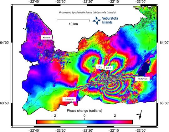
The latest processing of satellite imagery from sentinel-1 received this morning. It shows more entry than previously observed in the area in the last few days and in the area where the greatest seismic activity has been.
As of the time of this writing no volcanic surface activities have begun. However this can change with little to no warning.
If an eruption were to occur, it would likely be similar to Hawaiian style eruptions, with a fissure opening and lava oozing out at slow pace. The threat to human life, given the location will be minimal. The main effects in the area could be acrid air caused by SO2 and Florine gases, with the slight possibility of lapilli fall.


Iceland media has reported that the dyke width has increased by some 20cm after the large quake, which may have widened the magma corridor. This could mean that further quakes could be unlikely if the magma no longer requires rock-fracture events to advance upward out of the crust.
