Reykjanes, Iceland is experiencing another major quake swarm, with the largest quake so far at magnitude 5.7. The swarm is in the same general area as previous seismicity within recent years, and is very probably related to more magma intrusion. Magma intrusion and system inflation has been going on for about two years in this area, which is frequented by tourist visiting the famous Blue Lagoon resort spa.
Screen snip from Iceland Met Office website showing the large quake swarm. Green stars denote temblors larger than magnitude 3.
The quake swarm is assumed to be related to the inflation of the
Reykjanes volcanic system, however the area is host to numerous volcanic centers, and it is unclear whether they are also being activated by the recent magma intrusions. In the same area as the quake swarm is the Krisuvik volcanic system, and the Pleistocene Fagradalsfjall system. To the slight East of the swarm, there is the Brennisteinsfjöll system as well.
Icelandic news
has reported that after an overflight of the Reykjanes area, new steaming vents have opened up under cooled lava flows, and could be seen from the air. A hazard level
has been declared, to give the local authorities the tools they need to coordinate disaster management activities should more tremors cause damage to nearby towns, or, if an eruption should occur.
Eruptions in the area have occurred in historical times, with the
most recent confirmed eruption occurring in 1830. The last quake of similar magnitude was a 5.6 quake that was followed by some 1,700 aftershocks in late October of 2020. This did not result in an eruption, however deformation was recorded, including uplift of several cm. Gas odors have also been reported after the large quakes, which suggests that either rock fracture is releasing stored gases, or new magma is increasing gas venting.
In either case, magma is certainly involved, and if the area continues to experience large dike intrusions, the likelihood of an eruption in the area increases with each swarm.
It is unclear whether this sequence will lead to an eruption. Reports from
Jon Frimann's blog suggest that Iceland has raised the aviation color code over Reykjanes to Yellow (caution), so it does seem that at least some people think the situation warrants watching.
An eruption would probably threaten the Blue Lagoon, the town of Grindavik, and possibly the towns north of the eruption with pahoehoe lava flows, and gases. While submarine eruptions have had episodes of VEI 3-4, the land eruptions have been largely effusive, so it is probably not going to be the same as when Eyjaflallajökull or Grimsvötn erupted with large ash clouds.
*****UPDATE 2/26/2021*****
The quake swarm at Reykjanes continues, with renewed vigor this morning as several temblors over magnitude 4 have struck the region near the epicenter of the 5.7 quake of Wednesday.
Chart of today's more vigorous activity from Iceland Met Office.
It is unclear at this time whether the quake swarm is related to movement of magma, or regional faulting. The sheer number of quakes has created data problems for IMO, who are having some difficulty in cleaning the data up.
The more intense activity today suggests that this may continue on for some time. An eruption is certainly a possibility if the intense activity sustains, and if the Reykjanes/Krisuvik system is injected with more magma.
For now, all anyone can do is watch and speculate. The reality is the quakes themselves do pose dangers in the area from rockslides, falling rocks, ground cracking, and infrastructure damage, which is certainly enough to cause some problems.
*****UPDATE 3/1/2021*****
Magma injection at about 6km depth has now been confirmed on Reyjkjanes Peninsula between the Reykjanes and Krysuvik volcanic systems. This was confirmed by IMO, and their
post can be seen here in Icelandic.
The English translation reads:
Quake-hit Reykjanes peninsula still ongoing
New evidence gives reason to take a closer look at the scenario facing a dynamic intersection beneath the area of Mount Fagradals
1.3.2021
Updated 01.03. at 18.15
The Scientific Advisory Council met at a remote meeting today to discuss the earthquake in the Reykjanes peninsula. The meeting was attended by representatives from the Icelandic Meteorological Office, the University of Iceland, the Environment Agency, Isavia-ANS, HS-Orka and ÍSOR.
Until the meeting, the Bureau of Meteorology's automatic earthquake system has measured about 1800 tremors since midnight, and they are mostly confined to areas SW of Keili and Trölladyngju. Of these 1800, 23 are magnitude 3 or larger, and about 3 tremors are 4 in size or larger. The largest from midnight was measured at 16:35, 5.1 magnitude and originated about 1 km ASA at Bowling.
The Scientific Council also reviewed satellite images (InSAR) received today. Processing from those images shows more entry than previously observed in the area in the last few days. The most likely explanation is that the dynamic is forming under the area where the greatest seismic activity has been in the last few days. This new data will be better processed, including modelling in order to shed clearer light on the progress of cases.
In light of these new data discussed at today's scientific council meeting and experts have reviewed, it is important to take a closer look at the scenario facing a dynamic intersection under the area at Mount Fagradals.
Possible scenarios:
- It will reduce seismic activity in the coming days or weeks.
- The devastations will be increasing with larger tremors up to 6 magnitude in the vicinity of Mount Fagradals
- Tremor of sizes up to 6.5 occurs in the Sulfur Mountains
- Dynamic interjections continue in the vicinity of Mount Fagradals:
- Dynamic insertion activity decreases and dynamic clots
- Leading to a flow eruption with lava flows that probably won't threaten settlements
Current activity in the Reykjanes peninsula is sectioned and it is difficult to predict accurate progress and whether one scenario is more likely than another. New data is expected later this week that may shed clearer light on the reasons for this push. The Scientific Council will meet again tomorrow to further evaluate the available data as well as evaluate new measurements.
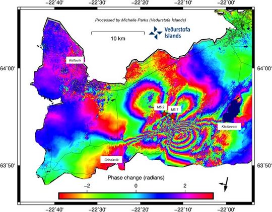
The latest processing of satellite imagery from sentinel-1 received this morning. It shows more entry than previously observed in the area in the last few days and in the area where the greatest seismic activity has been.
*****UPDATE 3/4/2021*****
The IMO has raised the alert level of the Krysuvik central volcano on the Reykjanes peninsula to ORANGE as seismicity, and tremor remains sustained. Iceland is expecting that an eruption may occur in the area between the Pleistocene Fagradsfell volcano and
the minor volcanic tuya of Keilir.
As of the time of this writing no volcanic surface activities have begun. However this can change with little to no warning.
Iceland authorities have stated they do no expect that any eruption in this area will threaten any human settlements or infrastructure, however this is only a guess at this time.
RUV.IS has posted a link to its live camera feed of the suspected area where an eruption may break out.
You can view that here.
The quakes and tremor continue with many quakes above 2.0 magnitude, several above 3.0 magnitude, and about 2 so far today above 4.0 magnitude.
If an eruption were to occur, it would likely be similar to Hawaiian style eruptions, with a fissure opening and lava oozing out at slow pace. The threat to human life, given the location will be minimal. The main effects in the area could be acrid air caused by SO2 and Florine gases, with the slight possibility of lapilli fall.
An eruption in this area would be significant only in the fact that that the Krysuvik system last erupted some 680 years ago, which would make this the first contemporary eruption in the area. Records in Iceland's historical archives record multiple eruptions that have occurred in the area since Vikings and settlers populated the area in the late 800's.
You can monitor the activity on Iceland Meteorological site at
this link.
*****UPDATE 3/5/2021*****
No eruption has started yet despite some confusing reporting. New magma has been confirmed in the system, and
is suspected to be at a depth of about 1.2 miles, or 2km, in a vertical magma dyke somewhere between Fagradalsfjall and Keilir Pliestocene volcanoes. However, reports have also suggested that magma may be rising in several volcanic systems on the peninsula, and not just Fagradalsfjall.
An article on mlb.is
suggests that the magma has also shifted away from Fagradalsfjall to the SW, and could conceivably erupt in the Reykjanes volcanic system. Models have actually suggested that if an eruption were to occur here, this would threaten the famous Blue Lagoon (Bláa lónið), as well as the Southern town of Grindavik, which was previously assumed to be safe from the activity.
It is still too early to accurately tell whether an eruption is absolutely certain, and where it will erupt from. But if trends continue, an eruption is likely.
It will be interesting to see what Iceland does if lava threatens Grindavik. Previously on the island of Heimaey, in 1973, the Eldfell volcano erupted and lava threatened the main harbor, which would have effectively cut off the residents from their livelihoods.
Icelanders fought back the lava flows with large seawater pumps, creating a cooled lava wall that actually ended up improving the safety of the harbor. While many homes were lost to the eruption, the Icelanders were able to save the main source of income for the island, preserving its way of life, and achieved for the very first time, a successful effort to stop of divert a lava flow.
If the town of Grindavik becomes threatened with encroaching lava, it will be interesting to see what Icelanders come up with. Grindavik is a coastal town, so it probably wouldn't be too big a challenge to install pumps that could cool a slowly advancing flow.
In any case, if an eruption does happen, we likely won't see it for a few days to weeks. And sometimes, activity like this doesn't end up resulting an eruption at all. Which of course is frustrating to those living in the area under that kind of uncertainty.
*****UPDATE 3/7/2021*****
Fagradalsfjall had a magnitude 5.0-5.2 (depending on if you're referencing IMO or USGS, respectively) tremor last evening, followed by a spurt of 3.0-4.0 temblors. A brief period of harmonic tremor was recorded which lasted for about 20 minutes.
Earthquake activity has shifted again to the WSW, and the dike intrusion is progressing at a steady but not breakneck pace. While an eruption is still likely to occur if seismicity persists, it is still not certain, and now, the seismicity is decreasing at a noticeable rate throughout the day.
A screengrab from IMO clearly shows the diminishing frequency and strength of quakes, however the left side of the graph shows a similar lull in activity before renewed, more powerful, and numerous quakes.
The lull in activity is very likely temporary, but of course this is not certain. All that can be said for now is that the energy in the swarm had a nice jolt about 48 hours ago now, but that it has since diminished significantly.
Deformation and GPS results in conjunction with INSAR measurements will probably be more crucial as time goes on, as many fissure eruptions are not necessarily detectable by seismicity alone. On the big island of Hawaii, in 2018, a quake series was detected under Leilani Estates, preceded by droppage in Halema'uma'u's lava lake. The quakes stopped after some time, and fissures quietly opened and began to issue lava flows of older, cooler magma from previous intrusions first, then, younger, hotter magma was able to escape, which caused faster flowing lavas. The resulting eruption left over 700 homes buried when the lava finally stopped flowing.
Whatever does happen in Iceland's Reykjanes peninsula, it will be of immense scientific interest, and hopefully, not a major threat to any human settlement. But as the eruption of Kilauea should teach us, you cannot predict what Madam Pele is going to do.
*****UPDATE 3/9/2021*****
Two periods of tremor have occurred within the past 48 hours. Just about an hour ago,
a 4.0 magnitude temblor struck the SW area of Fagradalsfjall. Seismicity has been on the upward trend for the past several hours, with little sign now of slowing down. If the dike intrusion does not erupt during this swarm, it will become increasingly likely with ever subsequent tremor episode, as the magma is now thought to be less than 1km below the surface.
Screenshot from IMO showing an increase in seismic energy and quake frequency to the right.
While it cannot be predicted when the eruption might begin, it is looking more certain that one will happen in hours, days, or weeks.
**A 5.1 magnitude quake just struck, the strongest to hit the area in weeks. This was followed by a 4.5 and many smaller quakes below 3.0.
*****UPDATE 3/15/2021*****
Last evening there was a large 5.4 magnitude quake, followed some 24+ hours later by a ~4.3 magnitude quake. Many smaller quakes have occurred, however their frequency is diminishing quickly.
This could a be a precursor to the actual eruption. Quakes are not necessarily prevalent before the onset of a fissure/dyke eruption, as the ground may already have the cracks necessary for the magma to seep up through.
Iceland media has reported that the dyke width has increased by some 20cm after the large quake, which may have widened the magma corridor. This could mean that further quakes could be unlikely if the magma no longer requires rock-fracture events to advance upward out of the crust.
This is of course, not certain, as surges of magma injection can renew quakes at any time, or the weight and displacement factors of the magma dyke can spur more 'trigger tremors'.
It is now likely only a matter of time until an eruption occurs. There are no signs suggesting that the magma injection has slowed, or that the dyke intrusion has slowed its advance toward the surface.
An eruption can occur without warning, or maybe it gives a short one. Either way, it is increasingly like that one will occur.
*****UPDATE 3/17/2021*****
The quake activity has notably decreased after a 3.6 magnitude temblor struck the Fagradalsfjall area earlier today. After this quake, subsequent quakes have been few, and much lower in magnitude, with only 1 measuring 2.0 in the last several hours.
Graph from IMO showing the decreasing severity of the quake swarm in Reykjanes Peninsula.
Tremor, however, continues to indicate magma injection into the dyke between Keilir and Fagrdalsfjall, with
reports of cracks appearing in the presumed intrusion area.
It is important to note that quakes occur due to the displacement of earth and crust, and do not necessarily indicate where magma is in the shallower depths. If the crust has been sufficiently weakened to the point that magma can ascend unimpeded by surface rock, it will not generate quakes. A similar situation occurred during the 2018 eruption of Kilauea volcano on the big island of Hawaii. Prior to lava erupting from fissures, seismicity notably decreased, and the lava quietly began to effuse in the Leilani Estates neighborhood.
It is unknown whether the current seismic decline in Reykjanes Peninsula means that an eruption is imminent, or won't occur at all. Only time will tell. In the meantime, the nearby towns are on edge.


No comments:
Post a Comment
Comments are moderated. See the comment policy for details.