Monday, April 5, 2021

Second Fissure Opens Up At Fagradalsfjall (UPDATE - THIRD FISSURE ERUPTS)

REYKJANES PENINSULA, ICELAND - An approximately 200 meter long fissure has opened up to the SW of the first eruptive vents at Fagradalsfjall at approximately noon Iceland time on April 5th. The fissure opened up some 200 meters from a rescue and aid camp that was set up nearby, which was quickly dismantled and moved.


New fissure outbreak at Fagradalsfjall.


The new fissure can be seen below in relation to the main vent, with lave spilling down a valley to the ENE. 


New fissure on the lower left. (Photographer unknown)

A new fissure opening likely indicates that this eruption is far from over, and that more fissure outbreaks are possible. Nothing in the data seemed to indicate anything like this was about to occur, so it comes as a shock to the scientists working on the data at Reykjanes Peninsula.

Camera 1 from FUV.is now points to the new fissure:  Live from Geldingadalir volcano, Iceland - YouTube

Camera 2 is pointing at the older, main vents: Volcanic eruption in Iceland! Live - Monday 5th - Camera 2 - YouTube

Due to the dynamic nature of this eruption, people should take extreme caution, and heed the direction of authorities. New fissures opening in the area can do so without warning, as these typically don't produce much in the way of detectable seismicity or tremor.

Speculation has gone on for weeks whether this slow effusion of lava was going to peter out, but it seems as though this new volcanic system may be just getting started. 

Some have theorized that the new fissure may decrease pressure on the original eruption site, and cause it to die out, but I'm not quite certain about that. The new lava breakout is at a higher elevation, so it stands to reason that there is still sufficient magma pressure in the dyke system to continue the effusive eruption at the original site. At this time, effusion remains steady, but lava fountaining is at a slightly lower level. 

The new fissure is directly draining lava into a nearby valley named Meradali, where it is rapidly pooling on the valley floor, forming a lava delta.


Meradali valley with the new lava delta. Photographer unknown. 

Maradali valley, like Geldingadaulur, is not close to any human settlements and lava is not expected to affect any structures or infrastructure at this time. 

Gas emissions in the area are significant, and the area has been closed by authorities and will not open at 6am as normal. Residents in areas affected by vog (volcanic fog) should remain indoors, with their windows and doors shut. People with breathing conditions should not venture outside. Vog is SO2 gas, and when combined with moisture turns acidic and can damage the lungs. 

Another webcam view of the fissure, with, presumably, the Geldingadaulur eruption to the left, and the newer fissure to the right (hard to tell):


*****UPDATE 3/5/2021*****

The new fissure continues to emit lava at a fast pace. This fissure seems to be stronger at onset than the previous fissure (now affectionately referred to as "bob", the new fissure is now called "Flo" tentatively by netizens). The smaller vents now appear to be inactive (the smaller of the two new fissures) or overcome by the lava flow as to mask its exhalations. 

Lava is swiftly filling the below valley of Maradali, and previous service roads which earlier saw a procession of motor vehicles departing the area has now been overcome by the advancing flow. While it is difficult to tell from the webcam alone, probably some 5-10% of the valley floor is now covered by the new lava.

Lava continues to rapidly descend down the valley channel that was established early on. There are some indications of the formation of temporary or permanent lava tubes as flowing lava builds a chute of sorts as its cooling surface welds itself into a ceiling. These are prone to frequent collapse as lava flow rates change. 


Dawn view of Maradali lava delta being emplaced by the new fissure (Screenshot from Ruv.is Youtube Feed).

The eruption at Geldingadaulur valley continues, with steady effusion of lava, and frequent collapse events from the brittle spatter cones which have formed into two distinct vents.

The 'right' vent (as seen on the current webcam view) continually builds a 'roof' which frequently collapses. It's lava fountaining level is muted by the fact that this roof develops, and over time, it is destroyed and rebuilt again.

The 'left' vent of "Bob" is prone to frequent crater wall collapses followed by periods of spattering that rebuild the collapsed structures. Despite predictions by some that this may eventually lead to a merged vent, I see this as unlikely due to the rate of spatter, and the fact that the camera angle at current does not really show the true distance between the left and right lava channels. It is about twice as far as it appears on camera. 

The new fissure vents are rapidly building ramparts and creating the foundations for a larger cone, if the outside spatter begins building one. At current the lava has an easy path to the below valley of Maradali, however this flow can redirect at any time. It is possible that lava builds a levee or joint in the flow that begins to send lava in another direction. 

The most likely channel for this is the 'rear' (or opposite of the current direction of flow) of the fissure. If the cone begins to build internal barriers from the other vents and create a 'compound cone', it is entirely possible that a lava 'spine' is created between two vents, deflecting ballistic lava bombs in the opposite direction. 

Such a structure would be prone to frequent collapse, and and deflected lava bombs would likely be much cooler in temperature than lava directly issued by the vents. In this scenario, the 'rear' of the vent would likely issue more blocky-type lava flows consisting of shattered lava bombs and pahoehoe clinker, which would travel at a slow rate.

It is still to early to tell whether or not this new fissure has the staying power of "Bob", but the next 24-48 hours will likely shed a lot of light on the nature of the eruption. 


*****UPDATE 4/6/2021*****

A third fissure has just opened up somewhere between "Bob" and "Flo. This occurred at 12:08am Iceland time. It opened suddenly and is currently issuing lava. The fissure is still expanding at the time of this writing, and it is unclear how large it may grow. The area it is erupting in is between Geldingagaulur, and Maradali.


The new vent can be seen nearly in between the 1st and 2nd eruptions. 

Given this new development in such a short period of time from the "Flo" breakout (less than 48 hours), it is likely that the area will become off limits. 

You can watch live feed of this eruption here: Live from Geldingadalir volcano, Iceland - YouTube

UPDATE 2:

The lava from the new fissure vent is rapidly approaching Geldingadaulur and is about to enter the valley. The vent opened quite close to Geldingadaulur.


The new vent can be seen to the far left, and the new flow moving towards Geldingadaulur.

It now becomes more probable that Geldingadaulur rapidly fills up, or at least at an increased pace, and may begin to flow into other valleys. It is also possible that more fissures can open along the same lineament as the three current eruptive vents. 

Lava is encroaching on the MBL.is webcam, and it may be on borrowed time. 


A replay was posted on Youtube from the original cam angle, showing the birth of the fissure. You can see it here.

The lava flow from the new fissure is beginning to pool on lava issued by fissure 1 (Bob). 


The lava is of the same characteristics of all other fissures, and is part of the same system. If lava continues to drain into Geldingadaulur, it may redirect or augment the flow of the first vent, accelerating the filling and spillover of Geldingadaulur to adjacent valleys. 

The lava pool from the 3rd fissure and the original Geldingadaulur fissure are now beginning to merge.


Activity at the original fissure appears to be reinvigorated with frequent fountaining, however the output seems to be a bit reduced in regards to lava outflow. It is hard to tell given that certain angles of observation are no longer available near the extremes of the new lava fields.

*****UPDATE 4/7/2021*****

The webcam run by MBL.is did indeed get consumed by lava last evening, as MBL reports. 

Webcam views this morning are obscured by snowfall for the most part, but reveal that the new fissure has already begun to build a spatter cone. The valley of Meradali has been partially filled by the lava from the 2nd fissure, although its spread appears to have slowed considerably.

As weather is not good for viewing at current, and the area is likely off-limits to visitors, the webcams are the only monitoring source at this time. 

An aerial shot was provided by MBL.is which gives a pretty good view of the three active vents.


From right to left, fissure 1, fissure 3, fissure 2. 

A new lava field map has been issued which shows the approximate location of the new lava fields.

*****UPDATE 3/7/2021*****

The eruption may be coming to a close, but it is too early to tell. All three vents are now displaying a low level of activity according to webcam observations. The vents that have opoened up are only showing light spattering at the moment, and are not issuing any strong lava flows.


Screengrab from RUV.is' webcam showing non-eruptive activity.

While the original vent (Bob) still shows some spatter activity, it is now very subdued. 

There are a few likely scenarios:

- The eruption is coming to an end and future eruptive activity might be preceded by further dyke intrusion events.
- The eruption is recharging after a gap in activity and may resume
- The eruption migrates to the NE and erupts in a new location 

As of now, it is too soon to tell. The next few days and weeks will inevitably give more data.

*****UPDATE 4/8/2021*****

The eruption continues with renewed vigor this evening as the 1st and 2nd vent display elevated lava effusion. New lava flows from vent 2 are descending down the valleys once more, while vent 3 shows weak spattering and viscous lava flows. Vent 1 (Bob) is displaying constant pahoehoe flow, with weak spattering and occasionally strong ejections of lava bombs.


Flo Cam from RUV.is showing vent 3 at the right, vent 2 in the middle (faint) and vent 1 at the far left.


Vent 1 (BoB) showing weak lava bomb ejection with strong lava effusion.

Seismicity remains low with few quakes above 1.5 magnitude being detected. Within the last several hours, no detectable quakes on the peninsula have occurred.


From IMO - seismicity is low or nonexistent for the past several hours.

Tremor is also low. This could indicate that the eruption has stabilized, and that further dyke intrusions are not occurring at the moment. This can change at any time. 


Friday, March 19, 2021

ERUPTION In Iceland! Fagradalsfjall ERUPTS

 About 1 hour ago, Mount Fagradalsfjall erupted. Some webcams are able to see the eruption including this one. Color video (not the best shot) can be seen here. A camera from RUV.is is here


Location of the new fissure from MBL.is


A massive glow can be seen above the mountain, in the area that was predicted to be the most likely spot for an eruption to occur. 


Fissure vent is feeding pahoehoe lava flows.


Screengrab from the IPCAMLIVE 


Image from Icelandic Coast Guard chopper aerial flight. 


A helicopter is apparently flying around as can be currently seen in webcam video.

While it is nighttime, it is impossible to see how high the lava fountaining is at the moment.

The Iceland MET Office has confirmed the eruption.

As stated in a previous post, it is not uncommon for quakes to stop, or slow once an eruption is imminent, and that was the case here. Seismicity dropped to lower levels with very few large quakes. Some scientists believed that an eruption would not occur. Others are theorizing that this may be a new phase for the entire peninsula. Seismicity is still quite low, even with lava now escaping to the surface.

Current seismicity remains lower than the last several weeks.


It is not known how long this eruption may last for, or where the new lava flow models predict that lava will go. We will likely know more once the sun rises in Iceland and more coverage begins. 

There are a few possibilities:
- The eruption is short-lived, lasting only hours to days
- The eruption gains a steady, deep supply of magma and erupts for weeks, months, or years
- The eruption occurs in phases, in fits and starts, until ceasing altogether

As magma is theorized to still be coming into the dyke system, this eruption will likely at least last for a week or two, although it is anyone's guess at this point.

Currently, the magma appears to be fast-flowing pahoehoe style lava, similar to Hawaiian eruptions. Lava this fluid may travel fast.


I will update this post separately from my previous post on the quake swarm, as an eruption is now underway, however if you'd like to refer to the lead-up to the eruption, you can see my previous coverage here. 

*****UPDATE 3/21/2020*****

The eruption at Fagradalsfjall continues. It is as expected, a low-threat eruption with little to no ash emissions. Iceland has cancelled the aviation warning. Many people are showing up to the sit to view the eruption up close. While the eruption may seem safe, this is not advised. New cracks, fissures, or vents can open at any time, as was the case in the Leilani Estates fissure eruption on the Big Island of Hawaii. People should avoid the area, and only take helicopter tours if possible. Of course, you cannot completely deter thrill-seekers, and this would be difficult to control around the clock.

The lava cone that has become the main vent collapsed earlier, spilling out a large pahoehoe flow which is advancing off-camera at ruv.is. It is unknown at this time whether this means the lava flow has found a new outlet and will drain further out of the main area. As lava flows cover the initial zone, it will create ledges, and lava will find a way to its lowest point. If the lava flows continue for weeks or months, it will likely flow to the lowest area it can find. 

This part of the eruption is expected to last from days to weeks, but probably not much longer unless another large injection of magma feeds into the current system. Flow rates fluctuate slightly, but overall the eruption appear consistent in its flow rate. 

Minor Strombolian and major pahoehoe effusive activity is occurring at the moment, with little to no change since the onset of eruption, although the number of active vents has now been reduced to around three or four. 

The fact that pahoehoe is the main product of this eruption strongly suggests a mantle source, as this would not be 'old' magma erupting as lava, however that is yet to be determined by volcanologists. Lava samples are needed to determine crystallization, gas, and other metrics to show whether this is older lava that has been forced up by newer magma, or if this is a mantle sourced 'new' channel. 

*****UPDATE 3/22/2021*****

The eruption continues at Fagrdalsfjall. The new eruptive center has been named for the Geldingadaulur valley, which roughly translates into 'Castration Valley' in English. While the eruption has occurred in Fagradalsfjall Pleistocene volcano, some sources theorize that the eruptive fissure is sourced from the more recent Krysuvik-Trolladyngja volcanic system, some miles to the East. However this is yet to be determined, as no chemical analysis is yet available, and data is still coming in.

What we do know at this point, is that base don historical data, activity in Reykjanes peninsula seems to come in long phases, followed by long periods of rest. It seems that the last period of rest is over. Some volcanologists and bloggers suggest that this could be the start of a new 'volcanic dynasty' in Reykjanes, or that eruptions should take place nearly every year for the next several hundred years. 

I do not share that assessment, although it is too early to tell. In my own opinion, volcanism from this vent will continue for several weeks, to perhaps more than a month, followed by a period of quiet, perhaps more than several years, before another monogenetic event breaks out. This might continue for a couple of decades or so, with rare, but predictable events occurring down the peninsula. However there is no concrete evidence at this time that points to a prolonged volcanic period on the peninsula.

I of course could be flat wrong here, however I don't think that current events indicate a 'major' change in activity, but perhaps a rare avenue for a minor magma surge to emerge and create a spectacle. 

This of course could change if major activity resumes after the eruption halts, or if a major tectonic event opens up wider avenues for magma to flow up to the surface. In any case, the current spectacle is simply amazing, and fun to watch. It is fortunate this eruption has not impacted any communities, and provided a bit of excitement for locals and media during what is probably the worst last couple years in human memory with the misery of COVID-19. 

You can watch the eruption on YouTubelive from RUV.is below.


*****UPDATE 3/23/2021*****

A mantle source for the lava currently being erupted in Geldingadaulur has been confirmed, which completely changes the calculus for Iceland regarding the eruption. Fluid lava is issuing at a steady, if not increased pace at the current vent area, which now consists of a ~400 meter high lava cone (prone to frequent collapses yesterday), with an insulated lava vent on its side. A second vent opened up (to the left on the above camera) which is vigorously issuing lava at around the same rate as the 'main' vent. 

It is now being theorized that due to the steady effusion, and fluidity of the magma, that this comes from a mantle source some 40-km deep (or deeper), and that this magma freshly broke through the crust, and could be a distinct magmatic system from nearby volcanoes like the Krysuvik-Trolladyngja system. 

If this is true, Iceland could be in for a very long eruptive period with a shield-building event not unlike the long eruptions in Hawaii. When magma finds a steady channel to the surface, there is not a lot that will stop it from continuously flowing to the surface. The only things that could stop the eruption would be that magma injection slows to the point it can no longer erupt, and the dyke that was feeding the lava to the surface cools. This does not appear to be a likely outcome any time soon. If anything the rate of flow has increased since the onset of the eruption.

The other option is that this is a long-lived monogenetic event that persists for years, not unlike the Paricutin eruption in Mexico.

Gas in the area is now extremely hazardous as the winds have died down somewhat, and the lava field grows. Icelandic authorities are having to station police and emergency personnel near the eruption site to keep people from getting lost, or putting themselves in danger to see the volcano. It is advised that if you want to watch the eruption, simply stream it rather than putting yourself at risk.  

New satellite imagery of the eruption site was also released by MBL.is today (image below)


NASA image of the eruption site.

*****UPDATE 3/24/2021*****

The eruption at Fagradalsfjall/Geldingadaulur continues. Effusive eruption continues at a steady rate, with no signs of weakening as of yet. Pulses of extremely vigorous emission have been observed. There have been several instances of lava tubes forming on the flanks of the main cone, which is now joined to a more vigorous, elongated vent which is just as active as the former main vent, if not more so.

The lava is pooling in an area with no outlet at the moment, so over time, lava channels will probably redirect the the lowest point on a perched table, which may speed up lava advances to lower valleys like the originally speculated eruption location of "The Night Pasture", or Nátthagi valley (Icelandic translation is not perfect here). If lave begins to enter this valley, it would likely become a main exit for new flows, but that of course could change if vent structure does. 

For now, the lava is pooling in a relatively safe area, with no threat to infrastructure or residents. It could probably not have erupted in a more convenient area, which is quite fortunate for the town of Grindavik, which is the nearest to the eruption site. 

*****UPDATE 4/1/2021*****

The eruption continues, with no sign of slowing down in terms of lava output. Tremor remains variable, and several quakes of up to magnitude 2.9 have occurred in the last several days. No news yet on whether deformation changes indicate any change in the rate of eruption, or any indication of whether or not this will continue for a long time.

Geldingadaulur vally is nearly filled with lava. A recent article by MBL.IS has posted the below photo of the current amount of lava filling the valley as seen on 3/31/2021. 


Photo from RUV.IS showing the extent of the lava in Geldingadaulur valley.

The eruption will likely continue until the magma pressure is cut off, and the surrounding cooler rock solidifies the magma dyke. If the eruption continues, with mantle driven magma, there is every chance that the dyke will erode and melt its boundaries, becoming wider. If this indeed mantle driven magma from a deep source, this could indeed create a larger magma channel over time, if the pressure persists.

If a new, large magma channel is formed, this can create a shield volcano over time. Although it is too early to tell, some have speculated that this is the birth of a shield style eruption.

However, it should be noted that a similar eruption in Mexico of the Paricutin volcano, was similar in many ways. This could be a 'monogenetic' event where a new lava/spatter/cinder cone/lava dome is formed, and never erupts again. 

The Reykjanes Peninsula is riddled with monogenetic cones with large lava flows. It stands to reason that this eruption might not be much different. But with volcanoes, and mantle-driven sources, the proof is only in the results, as we cannot truly see deep enough to know what to expect. This could end up being a very long eruption, the tip of something bigger, or a small eruption that entertained Iceland and petered out after several months or years. 

Hopefully, in the coming weeks and months, more and more data metrics will give a clearer picture of the mechanics of this eruption, and enhance volcano science for the better. It has been a long time since humans have witnessed a 'new' volcano being born, even if all of Iceland is in fact volcanic in origin. This remains an exciting event. 


Wednesday, February 24, 2021

Iceland Has Major Quake Swarm At Reykjanes Peninsula [UPDATED]

 Reykjanes, Iceland is experiencing another major quake swarm, with the largest quake so far at magnitude 5.7. The swarm is in the same general area as previous seismicity within recent years, and is very probably related to more magma intrusion. Magma intrusion and system inflation has been going on for about two years in this area, which is frequented by tourist visiting the famous Blue Lagoon resort spa. 


Screen snip from Iceland Met Office website showing the large quake swarm. Green stars denote temblors larger than magnitude 3.

 The quake swarm is assumed to be related to the inflation of the Reykjanes volcanic system, however the area is host to numerous volcanic centers, and it is unclear whether they are also being activated by the recent magma intrusions. In the same area as the quake swarm is the Krisuvik volcanic system, and the Pleistocene Fagradalsfjall system. To the slight East of the swarm, there is the Brennisteinsfjöll system as well.

Icelandic news has reported that after an overflight of the Reykjanes area, new steaming vents have opened up under cooled lava flows, and could be seen from the air. A hazard level has been declared, to give the local authorities the tools they need to coordinate disaster management activities should more tremors cause damage to nearby towns, or, if an eruption should occur.

Eruptions in the area have occurred in historical times, with the most recent confirmed eruption occurring in 1830. The last quake of similar magnitude was a 5.6 quake that was followed by some 1,700 aftershocks in late October of 2020. This did not result in an eruption, however deformation was recorded, including uplift of several cm. Gas odors have also been reported after the large quakes, which suggests that either rock fracture is releasing stored gases, or new magma is increasing gas venting. 

In either case, magma is certainly involved, and if the area continues to experience large dike intrusions, the likelihood of an eruption in the area increases with each swarm.

It is unclear whether this sequence will lead to an eruption. Reports from Jon Frimann's blog suggest that Iceland has raised the aviation color code over Reykjanes to Yellow (caution), so it does seem that at least some people think the situation warrants watching.

An eruption would probably threaten the Blue Lagoon, the town of Grindavik, and possibly the towns north of the eruption with pahoehoe lava flows, and gases. While submarine eruptions have had episodes of VEI 3-4, the land eruptions have been largely effusive, so it is probably not going to be the same as when Eyjaflallajökull or Grimsvötn erupted with large ash clouds. 


*****UPDATE 2/26/2021*****

The quake swarm at Reykjanes continues, with renewed vigor this morning as several temblors over magnitude 4 have struck the region near the epicenter of the 5.7 quake of Wednesday.


Chart of today's more vigorous activity from Iceland Met Office.

It is unclear at this time whether the quake swarm is related to movement of magma, or regional faulting. The sheer number of quakes has created data problems for IMO, who are having some difficulty in cleaning the data up. 

The more intense activity today suggests that this may continue on for some time. An eruption is certainly a possibility if the intense activity sustains, and if the Reykjanes/Krisuvik system is injected with more magma. 

For now, all anyone can do is watch and speculate. The reality is the quakes themselves do pose dangers in the area from rockslides, falling rocks, ground cracking, and infrastructure damage, which is certainly enough to cause some problems. 
    
  *****UPDATE 3/1/2021*****

Magma injection at about 6km depth has now been confirmed on Reyjkjanes Peninsula between the Reykjanes and Krysuvik volcanic systems. This was confirmed by IMO, and their post can be seen here in Icelandic.

The English translation reads:

Quake-hit Reykjanes peninsula still ongoing

New evidence gives reason to take a closer look at the scenario facing a dynamic intersection beneath the area of Mount Fagradals

1.3.2021

Updated 01.03. at 18.15

The Scientific Advisory Council met at a remote meeting today to discuss the earthquake in the Reykjanes peninsula. The meeting was attended by representatives from the Icelandic Meteorological Office, the University of Iceland, the Environment Agency, Isavia-ANS, HS-Orka and ÍSOR.

Until the meeting, the Bureau of Meteorology's automatic earthquake system has measured about 1800 tremors since midnight, and they are mostly confined to areas SW of Keili and Trölladyngju. Of these 1800, 23 are magnitude 3 or larger, and about 3 tremors are 4 in size or larger. The largest from midnight was measured at 16:35, 5.1 magnitude and originated about 1 km ASA at Bowling.

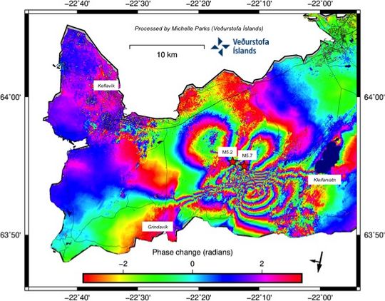
The Scientific Council also reviewed satellite images (InSAR) received today. Processing from those images shows more entry than previously observed in the area in the last few days. The most likely explanation is that the dynamic is forming under the area where the greatest seismic activity has been in the last few days. This new data will be better processed, including modelling in order to shed clearer light on the progress of cases.

In light of these new data discussed at today's scientific council meeting and experts have reviewed, it is important to take a closer look at the scenario facing a dynamic intersection under the area at Mount Fagradals.

Possible scenarios:

  • It will reduce seismic activity in the coming days or weeks.
  • The devastations will be increasing with larger tremors up to 6 magnitude in the vicinity of Mount Fagradals
  • Tremor of sizes up to 6.5 occurs in the Sulfur Mountains
  • Dynamic interjections continue in the vicinity of Mount Fagradals:
    • Dynamic insertion activity decreases and dynamic clots
    • Leading to a flow eruption with lava flows that probably won't threaten settlements

Current activity in the Reykjanes peninsula is sectioned and it is difficult to predict accurate progress and whether one scenario is more likely than another. New data is expected later this week that may shed clearer light on the reasons for this push. The Scientific Council will meet again tomorrow to further evaluate the available data as well as evaluate new measurements.


The latest processing of satellite imagery from sentinel-1 received this morning. It shows more entry than previously observed in the area in the last few days and in the area where the greatest seismic activity has been.


*****UPDATE 3/4/2021*****

The IMO has raised the alert level of the Krysuvik central volcano on the Reykjanes peninsula to ORANGE as seismicity, and tremor remains sustained. Iceland is expecting that an eruption may occur in the area between the Pleistocene Fagradsfell volcano and 
the minor volcanic tuya of Keilir. 

As of the time of this writing no volcanic surface activities have begun. However this can change with little to no warning.

Iceland authorities have stated they do no expect that any eruption in this area will threaten any human settlements or infrastructure, however this is only a guess at this time.

RUV.IS has posted a link to its live camera feed of the suspected area where an eruption may break out. You can view that here.

The quakes and tremor continue with many quakes above 2.0 magnitude, several above 3.0 magnitude, and about 2 so far today above 4.0 magnitude. 

If an eruption were to occur, it would likely be similar to Hawaiian style eruptions, with a fissure opening and lava oozing out at slow pace. The threat to human life, given the location will be minimal. The main effects in the area could be acrid air caused by SO2 and Florine gases, with the slight possibility of lapilli fall.

An eruption in this area would be significant only in the fact that that the Krysuvik system last erupted some 680 years ago, which would make this the first contemporary eruption in the area. Records in Iceland's historical archives record multiple eruptions that have occurred in the area since Vikings and settlers populated the area in the late 800's.

You can monitor the activity on Iceland Meteorological site at this link.

*****UPDATE 3/5/2021*****

No eruption has started yet despite some confusing reporting. New magma has been confirmed in the system, and is suspected to be at a depth of about 1.2 miles, or 2km, in a vertical magma dyke somewhere between Fagradalsfjall and Keilir Pliestocene volcanoes. However, reports have also suggested that magma may be rising in several volcanic systems on the peninsula, and not just Fagradalsfjall. 

An article on mlb.is suggests that the magma has also shifted away from Fagradalsfjall to the SW, and could conceivably erupt in the Reykjanes volcanic system. Models have actually suggested that if an eruption were to occur here, this would threaten the famous Blue Lagoon (Bláa lónið), as well as the Southern town of Grindavik, which was previously assumed to be safe from the activity. 

It is still too early to accurately tell whether an eruption is absolutely certain, and where it will erupt from. But if trends continue, an eruption is likely. 

It will be interesting to see what Iceland does if lava threatens Grindavik. Previously on the island of Heimaey, in 1973, the Eldfell volcano erupted and lava threatened the main harbor, which would have effectively cut off the residents from their livelihoods. Icelanders fought back the lava flows with large seawater pumps, creating a cooled lava wall that actually ended up improving the safety of the harbor. While many homes were lost to the eruption, the Icelanders were able to save the main source of income for the island, preserving its way of life, and achieved for the very first time, a successful effort to stop of divert a lava flow. 

If the town of Grindavik becomes threatened with encroaching lava, it will be interesting to see what Icelanders come up with. Grindavik is a coastal town, so it probably wouldn't be too big a challenge to install pumps that could cool a slowly advancing flow. 

In any case, if an eruption does happen, we likely won't see it for a few days to weeks. And sometimes, activity like this doesn't end up resulting an eruption at all. Which of course is frustrating to those living in the area under that kind of uncertainty. 

*****UPDATE 3/7/2021*****

Fagradalsfjall had a magnitude 5.0-5.2 (depending on if you're referencing IMO or USGS, respectively) tremor last evening, followed by a spurt of 3.0-4.0 temblors. A brief period of harmonic tremor was recorded which lasted for about 20 minutes.

Earthquake activity has shifted again to the WSW, and the dike intrusion is progressing at a steady but not breakneck pace. While an eruption is still likely to occur if seismicity persists, it is still not certain, and now, the seismicity is decreasing at a noticeable rate throughout the day. 

A screengrab from IMO clearly shows the diminishing frequency and strength of quakes, however the left side of the graph shows a similar lull in activity before renewed, more powerful, and numerous quakes. 

The lull in activity is very likely temporary, but of course this is not certain. All that can be said for now is that the energy in the swarm had a nice jolt about 48 hours ago now, but that it has since diminished significantly.

Deformation and GPS results in conjunction with INSAR measurements will probably be more crucial as time goes on, as many fissure eruptions are not necessarily detectable by seismicity alone. On the big island of Hawaii, in 2018, a quake series was detected under Leilani Estates, preceded by droppage in Halema'uma'u's lava lake. The quakes stopped after some time, and fissures quietly opened and began to issue lava flows of older, cooler magma from previous intrusions first, then, younger, hotter magma was able to escape, which caused faster flowing lavas. The resulting eruption left over 700 homes buried when the lava finally stopped flowing. 

Whatever does happen in Iceland's Reykjanes peninsula, it will be of immense scientific interest, and hopefully, not a major threat to any human settlement. But as the eruption of Kilauea should teach us, you cannot predict what Madam Pele is going to do. 

*****UPDATE 3/9/2021*****

Two periods of tremor have occurred within the past 48 hours. Just about an hour ago, a 4.0 magnitude temblor struck the SW area of Fagradalsfjall. Seismicity has been on the upward trend for the past several hours, with little sign now of slowing down. If the dike intrusion does not erupt during this swarm, it will become increasingly likely with ever subsequent tremor episode, as the magma is now thought to be less than 1km below the surface. 

Currently the best webcam angle, in my opinion, is located here on Ruv.is website. 

Screenshot from IMO showing an increase in seismic energy and quake frequency to the right.

While it cannot be predicted when the eruption might begin, it is looking more certain that one will happen in hours, days, or weeks. 

**A 5.1 magnitude quake just struck, the strongest to hit the area in weeks. This was followed by a 4.5 and many smaller quakes below 3.0. 

*****UPDATE 3/15/2021*****

Last evening there was a large 5.4 magnitude quake, followed some 24+ hours later by a ~4.3 magnitude quake. Many smaller quakes have occurred, however their frequency is diminishing quickly.

This could a be a precursor to the actual eruption. Quakes are not necessarily prevalent before the onset of a fissure/dyke eruption, as the ground may already have the cracks necessary for the magma to seep up through. 

Iceland media has reported that the dyke width has increased by some 20cm after the large quake, which may have widened the magma corridor. This could mean that further quakes could be unlikely if the magma no longer requires rock-fracture events to advance upward out of the crust.

This is of course, not certain, as surges of magma injection can renew quakes at any time, or the weight and displacement factors of the magma dyke can spur more 'trigger tremors'. 

It is now likely only a matter of time until an eruption occurs. There are no signs suggesting that the magma injection has slowed, or that the dyke intrusion has slowed its advance toward the surface. 

An eruption can occur without warning, or maybe it gives a short one. Either way, it is increasingly like that one will occur. 

*****UPDATE 3/17/2021*****

The quake activity has notably decreased after a 3.6 magnitude temblor struck the Fagradalsfjall area earlier today. After this quake, subsequent quakes have been few, and much lower in magnitude, with only 1 measuring 2.0 in the last several hours. 

Graph from IMO showing the decreasing severity of the quake swarm in Reykjanes Peninsula.

Tremor, however, continues to indicate magma injection into the dyke between Keilir and Fagrdalsfjall, with reports of cracks appearing in the presumed intrusion area. 

It is important to note that quakes occur due to the displacement of earth and crust, and do not necessarily indicate where magma is in the shallower depths. If the crust has been sufficiently weakened to the point that magma can ascend unimpeded by surface rock, it will not generate quakes. A similar situation occurred during the 2018 eruption of Kilauea volcano on the big island of Hawaii. Prior to lava erupting from fissures, seismicity notably decreased, and the lava quietly began to effuse in the Leilani Estates neighborhood.

It is unknown whether the current seismic decline in Reykjanes Peninsula means that an eruption is imminent, or won't occur at all. Only time will tell. In the meantime, the nearby towns are on edge.

Tuesday, December 29, 2020

Soufriere St. Vincent Volcano Begins To Build Lava Dome

***UPDATE 12/30/2020***

News coverage has begun reporting on the developments at Soufriere St. Vincent. Some reports are falsely posting articles which show an ash column above the volcano, however the eruption is purely effusive/dome building at this time and no explosions have occurred as yet. 

The alert level has been raised from Yellow to Orange, and scientists are intensely monitoring the volcano in an effort to give at least 48 hours notification to residents should an explosive eruption be imminent.

It seems that the island of Martinique has also decided to raise their alert level, as seismicity has recently been detected under the volcano. This is the first time the alert has been raised since its last eruption in 1932.

________________________________________________________________________________

Original article

 Soufriere St. Vincent in the West Indies islands, NE of Venezuela has begun exhibiting lava dome growth, after decades of silence, having last erupted in 1979 after years of activity. The current dome growth appears to be occurring at the South end of the main crater of Soufriere St. Vincent. Vigorous steaming was observed, followed by slow uplift of land between the 1970's lava dome, and the crater wall. 

A post from Facebook on the Vulcanología Esia page revealed the following sequence of events:

Image from Vulcanologia Esia Facebook group.

The last eruption of the volcano produced, in 1979, a VEI 3 scale eruption, and has had many eruptions of VEI 4 magnitude in the past.

Given scant news coverage of the volcano at this time, it is unknown how this eruption will progress. It could remain a mostly dome building, effusive event, or it could turn explosive if the dome event is succeeded by an explosive/pyroclastic event. 

This page will be updated as more details come in. 

The last major eruptive activity in the island chain was when Soufriere Hills on the island of Montserrat erupted unexpectedly, demolishing the capital city of Plymouth in 1995. Other submarine volcanoes may have exhibited minor activity recently, including the humorously named volcano, Kick 'em Jenny,


Sunday, December 20, 2020

Kilauea Roars Back to Life!

****BREAKING****

**UPDATE 12/28/2020**

There has been no significant change lately, except that weak summit inflation briefly dipped to deflation, and then back to inflation again. Down rift in the LERZ, the magma supply appears to be favoring the summit eruption, and gradual inflation is now trending towards deflation. 

The lava lake level has remained steady, and the 'island' of cooled rock that has been floating on the lava lake continues to circulate and shrink over time. 

The last active vent has 2-3 small steams of lava pouring out, and SO2 output has decreased significantly within the last day. 

All updates can be found here at Hawaiian Volcano Observatory (usgs.gov)

**UPDATE 12/26/2020**

The lava lake rose to the level of the North fissure, and appears to have stopped it. Lava appears now to be draining back into the fissure, as a 'crust ledge' has formed around the lava lake, and the molten lava is lower than the ledge. The East fissure is slowly spattering lava out back into the lake. It is entirely possible given these developments that the eruption ceases within the next several days or weeks, as the lava lake cools, and the pressure in the shallow magma chamber decreases.


Thermal Time-lapse from HVO on 12/26/2020 shows the inundation and 'death' of the North fissure, while activity from the East (lower fissure resumes).

Summit inflation has also slightly resumed, which could be due to the North fissure now being 'plugged' or receiving lava back into it. 


Summit changing from deflation to inflation, a DI event.

What this means for now is not certain, as this could be a minor inflation, deflation event, or could signal a positive pressure change. The next few days should be telling.

Down rift at Puʻu ʻŌʻō, a slight deflationary trend has been noted, likely due to lack of fresh magma supply as it erupts from the summit. 


**UPDATE 12/22/2020**


The lava lake continues to rise, and it's surface is just beginning to overtake the North fissure's edifice. Hawaii health officials have begun resuming 'vog' (volcanic fog) warnings to residents.

By tomorrow, a new dynamic in the lake should unfold as the magma source becomes lower than the lava lake surface. Spatter cones may form, the lava lake may continue to rise, or it may stop and simply circulate. There is no way of knowing at this point. Summit deflation is consistent with magma release, with the latest subsidence readings at about 0.10 meters in the last several days.

Deflationary event post-fissure eruption and lava lake formation. Copyright HVO.


Down rift to the Lower East Rift Zone (LERZ), the inflationary trend near the 1983-2018 Puʻu ʻŌʻō vent continues a steady upward inflationary trend, apparently unaffected by the summit action at Halema'uma'u caldera. Time will tell if eruptive activity resumes at both vents, although at this point, HVO does not seem overly concerned with this.

Current inflationary trend at Puʻu ʻŌʻō. Copyright HVO.


HVO had been weighing raising the alert level at Kilauea in recent days/weeks, and purportedly were about to do so the night of the eruption, when the eruption occurred suddenly. 

Neighboring Mauna Loa was raised to Yellow alert after the cessation of Kilauea's long-lived eruption which began in 1983 and ended in late 2018. 

Lava lake surface approaching main fissure vent during 12/21-12/22, 2020.

The next few days should give an indication as to whther this lava lake and eruption will be sustained, or short lived. A minor magma intrusion did occur earlier this month at shallow depth, and on occasion, these do result in minor effusive eruptions. 

More updates will follow. 

**UPDATE 9:06pm HST 12/21/2020**

The latest image shows that the lava lake has risen even further. The rate of rise has slowed either due to less lava output, or due to the diameter of the crater widening as levels rise. It appears at least one fissure is issuing lava from beneath the lava pool surface, while two fissures on the crater rim are continuing to issue lava as well. Earlier reports indicated one fissure had ceased, but it is difficult to tell from the images whether this is still the case.

It is still unknown how long the eruption will continue for, and whether other phases will occur.

At this time there is minimal danger to the public as, according to HVO, "The eruption has stabilized" and ash emissions have ceased. HVO lowered the aviation color code from RED to ORANGE in response, after the former water lake had been completely evaporated and lava/water interactions ceased. 


**UPDATE 12:05PM HST 12/21/2020**

Animated GIF From HVO shows the rapid rise of the lava in the crater.


**UPDATE 11:00am HST 12/21/2020**

The caldera floor has now been filled up to the N eruptive fissure, according to the latest Summit Webcam shot (the quality is low, and the HVO web server appears to be under some stress at the moment).

It appears the SW fissure may now be underneath the lava lake, and that the lava lake is now nearly up to the point of overtaking the largest fissure at the N wall of the caldera. The lava lake has greatly exceeded the level of the former water lake.

Image from approximately 8am HST


It is not known how long the eruption will continue.


 Image from about 11am HST

As you can see above, the lava lake is rapidly rising. If the eruption continues throughout the day, there is the possibility that it will overtop the new collapse crater and fill the caldera in further.


**UPDATE 8:00am HST 12/21/2020**

According to USGS, the eruption currently consists of three crater wall fissure vents, and the lake is completely gone. A lava lake is forming within Halema'uma'u crater. The eruption so far is limited to the summit, although it is unclear whether any activity may start down rift. 

The eruption in 2018 was spurred by rapid summit lava drainage down rift to Pu'u'O'O crater, which then drained further down the LERZ to the Leilani Estates area. Given that magma still exists down rift from that eruption, and that it is still reasonably hot, it is always possible that the 2018 system can receive a new injection of magma. 

It is too soon to tell what the return of a summit lava lake will mean, or if this eruption will be long lived, or a shorter episode resulting from the minor magma dike intrusion a couple weeks ago. The eruption could go for only days, or go for on for weeks to years. The previous eruptive period on Kilauea was from 1983-2018, with lava present first at  Pu'u'O'O, and then simultaneously with Halema'uma'u, ultimately resulting in the LERZ fissure eruption.


**UPDATE 11:57pm HST 12/20/2020****

Local News now reporting Hawaii Island erupting again, new eruption in Halema'uma'u (khon2.com)

A 4.4 Mag temblor was recorded downrift on the LERZ preceding the summit eruption. It is unclear how this is related at this time.


***UPDATE 11:09pm HST 12/20/2020****

HVO Has now raised the alert level to RED for Kilauea. Kīlauea - Volcano Updates (usgs.gov)

Shortly after approximately 9:30 p.m. HST, the USGS Hawaiian Volcano Observatory (HVO) detected glow within Halemaʻumaʻu crater at the summit of Kīlauea Volcano. An eruption has commenced within Kīlauea’s summit caldera. The situation is rapidly evolving and HVO will issue another statement when more information is available.

Accordingly, HVO has elevated Kīlauea’s volcano alert level to WARNING and its aviation color code to RED.

Alert levels and aviation color codes are explained here: https://www.usgs.gov/natural-hazards/volcano-hazards/about-alert-levels

HVO continues to monitor the volcano closely and will report any significant changes.

Stay informed about Kīlauea by following volcano updates and tracking current monitoring data on the HVO web page (https://www.usgs.gov/volcanoes/kilauea/volcano-updates) or by signing up to receive updates by email at this site: https://volcanoes.usgs.gov/vns2/.

HVO is in communication with Hawai‘i Volcanoes National Park as this situation, which is taking place within the park, evolves.

HVO is in contact with the County of Hawai‘i Civil Defense Agency.

Recent Observations:

For the past several weeks, the USGS Hawaiian Volcano Observatory (HVO) has recorded ground deformation and earthquake rates at Kīlauea Volcano’s summit and upper East Rift Zone that have exceeded background levels observed since the conclusion of the 2018 lower East Rift Zone eruption and summit collapse.

Beginning in September 2020, increased rates of uplift were observed by GPS stations in Kīlauea’s upper East Rift Zone. In the past month, increased uplift has also been measured at GPS stations in Kīlauea’s summit region. While uplift related to post-collapse inflation of the summit reservoir has been occurring since March of 2019, rates have been steadily increasing in recent months and are currently higher than they have been since the end of the 2018 eruption.

In late November 2020, increased earthquake rates began when seismic stations recorded an average of at least 480 shallow, small-magnitude earthquakes (97% of which were less than or equal to magnitude-2) per week occurring at depths of less than 4 km (2.5 miles) beneath Kīlauea's summit and upper East Rift Zone. This compares to a rate of fewer than 180 per week following the end of Kīlauea’s 2018 eruption and through early November 2020.

On December 2, 2020, GPS stations and tiltmeters recorded a ground deformation event at Kīlauea’s summit. Accompanied by earthquake swarms, the patterns of ground deformation observed were consistent with a small dike intrusion of magma under the southern part of Kīlauea caldera. The injection resulted in about 8 cm (3 inches) of uplift of the caldera floor, and modeling suggests that it represented 0.4–0.7 million cubic meters (yards) of magma accumulated approximately 1.5 km (1 mile) beneath the surface. Though the intrusion did not reach the surface and erupt, it represented a notable excursion from trends observed in Kīlauea summit monitoring data streams following the end of the 2018 eruption.

On December 17, 2020, seismometers detected a notable increase in occurrence and duration of long-period seismic signals beneath Kīlauea’s summit, which are attributed to magmatic activity. Whereas this type of seismicity was observed on average once every few weeks following the 2018 eruption, rates have increased to over a dozen in the past several days.

Other monitoring data streams including volcanic gas and webcam imagery were stable until this eruption.

An earthquake swarm began on the evening of December 20, accompanied by ground deformation detected by tiltmeters. An orange glow was subsequently observed on IR monitoring cameras and visually beginning approximately 21:36 HST.

***Original post below***

10 minutes ago HST, Kilauea has now roared back to life, according to HVO.


This marks the first resumption of eruptions from Kilauea since the cessation of eruptive activity after the 2018 Leilani Estates/LERZ eruption, which destroyed over 700 homes and displaced twice as many people. 

It is unknown what role the water lake has had in the eruption at this time, however according to the above image, it appears to have been vaporized. There appears to be no trace of it in new images, and due to the time of night, is it unclear if a phreatic eruption has occurred, which was hypothesized. 


Current screen grab from HVO's Kilauea Summit Cam


More news will follow.

Right now, you can follow the Facebook page of Hawaii Volcanoes National Park for updates.

Kilauea was previously at Green alert, after a little over two years of quiescence. Following the 2018 eruptive episode, long periods of inflation were recorded, including a recent dike intrusion event. These events were apparently not enough for HVO to become concerned that a new eruption may take place, even though the intrusion was quite shallow, as had been many recent quakes.

Hawaii Island has been hit both by the COVID-19 pandemic, as well as the recent eruption of Kilauea in its Lower East Rift Zone, which erupted in the middle of a neighborhood development, and near a geothermal power planet, the Puna Geothermal Plant. This plant only recently reopened for power generation, and it is unclear whether or not renewed activity at Halema'uma'u will change this.

I expect that the aviation color code will be raised to orange/red, and that the local code be changed accordingly as well in the next USHS HVO Update. 

This is a developing situation, and more updates will be posted as the eruption progresses.

Mauna Loa is also on Yellow alert at this time. A recent deflation event at the summit may or may not have contributed to pressurization of Kilauea, but it is possible. Mauna Loa had been consistently inflating until just a few days ago when a dike intrusion was detected at Kilauea Summit. Whether this is a true correlation is a mystery at this time. 

Residents near the volcano should heed the warnings of local authorities, and evacuate immediately if necessary. Kilauea's behavior of late is not exactly predictable, and quakes have been detected down-rift of last as well. A 2.8 quake, and many smaller magnitude, but still over 2.0 quakes had been detected today down to Mauna Ulu, the site of the eruption preceding that of Pu'u'O'O in 1983.

This is a rapidly developing situation, and many new updates will be posted. 

Hawaiian local news is not yet reporting on the eruption.