Thursday, March 5, 2015

Iceland's Bardarbunga Volcano Eruption Pauses

The long-running eruption of Iceland's Bárðarbunga volcano has paused, or ceased. Webcam footage no longer is showing any lava coming out of the eruptive fissure, and scientists visited the site to assess the landscape, only to find a degassing crater.

The stoppage of the eruption at Holhuraun fissure is likely not the end of the activity. As this is a rifting episode, it is likely that magma chamber re-inflation will eventually occur. Seismicity is ongoing, although a lot lower than it has been in recent months.

There is still plenty of quake activity along the eruptive fissure, and below the Vatnajöull glacier, and in the Bárðarbunga caldera.

The area will probably remain unsafe for some time due to degassing, residual heat and cooling lava, and brittle, sharp surfaces.

It is anyone's guess as to when or if activity will resume. If it does, you'll definitely read about it here!

Wednesday, March 4, 2015

Oklahoma Kept Silent About Fracking To Protect Industry

While it has long been known that 'fracking' byproducts and waste water well injections can and do cause earthquakes, it seems that in Oklahoma, that fact was suppressed to protect the oil industry. According to an article on Rawstory, University of Oklahoma President David Boren pressured subordinates to either downplay or remain silent on the issue after being pressured by oil executives.

Waste water well injections pump millions of gallons of chemical-laden liquid into 'waste water wells' which are simply very deep drill holes in the ground. These holes can go through many types of rocks, and old 'locked' fault lines, and once the chemical soup is down there, it can lubricate fault lines, weaken limestone and bedrock, and of course, pollute water tables and aquifers.

Fracking has increasingly become a more common practice in the oil and gas industry. Hydro-fracturing injects gas an water into shale tables in order to release trapped natural gases, which are harvested above ground. There are many reserves of this gas-shale across the US, which has led to a brief energy boom in the industry, which has seen very little regulation or restraint placed on these practices.

Unfortunately, it seems that good science has been suppressed in this case in the name of energy profits, and this has put lives and property at risk.

Where previously, there were little to no earthquakes in Oklahoma, their daily total of quakes now exceed that of my home state of California, both in number and magnitude. While California regularly experiences small quakes ranging from <1.0 to greater than 3.5 daily, Oklahoma's average quake magnitudes are exceeding magnitude 3.5 and in one case, a damaging 5.7 earthquake occurred along a now reactivated fault line.

This is part of a disturbing trend in the US, where 'scientists' can be paid to suppress research findings in the name of corporate profit, and part of a concerted effort by energy companies to publicly erode public trust in science itself. And the strategy is working.

In the US, public trust of science is on a sharp decline, in no small part because of powerful energy lobbyists, and oil barons the Koch brothers. David and Charles Koch own and operate Koch Industries, who re involved in everything from energy to agriculture. It has long been known that they heavily lobby and campaign for neo-conservtive politicians, and fund anti-science campaigns designed to 'discredit' unfolding disasters such as global warming, and environmental damage caused by energy extraction an exploration, in order to deregulate the oil industry and maximize profits.

It is an unfortunate state of affairs for good science, and a black mark on the human race. It is entirely outrageous that average people buy into the whole 'clean coal' myth, along with climate change denial because of tactics like this. Stuff like this gives me a conniption.

Tuesday, March 3, 2015

Chile's Villarica Volcano Erupts

Villarica Volcano in Chile has erupted for the first time in around 15 years, forcing evacuations. The volcano had been showing small signs of activity since early February, but this explosion was enough to force people to flee due to its intense but brief eruption.

The volcano was briefly raised to 'Red alert', but has since been lowered to 'Yellow' as activity has waned.

No injuries or property damage was reported, although ash fall was likely a nuisance to nearby residents.

According to the USGS/Smithsonian GVP:

"OVDAS-SERNAGEOMIN reported that activity significantly increased at Villarrica during 1-16 February, characterized by increased seismicity, crater incandescence, and explosions. On 6 February seismicity increased significantly, explosions occurred in the crater, and ash emissions rose above the crater rim. The Alert Level was raised to Yellow (the second lowest level on a four-color scale). DOAS (Differential Optical Absorption Spectrometry) data showed an average monthly sulfur dioxide emission value of 222 tons per day; a high value during this period of 450 tons per day was recorded on 11 February. The highest number of explosions, five per minute, during the period occurred on 16 February. Explosions ejected incandescent material out of the crater as far as 1 km onto the S flank. During an overflight on 16 February, supported by ONEMI, volcanologists observed the lava lake and recorded temperatures near 800 degrees Celsius, tephra in and around the active crater, and a diffuse layer of ash on the flanks."


The GVP describes the volcano here:


"Glacier-clad Villarrica, one of Chile's most active volcanoes, rises above the lake and town of the same name. It is the westernmost of three large stratovolcanoes that trend perpendicular to the Andean chain. A 6-km wide caldera formed during the late Pleistocene. A 2-km-wide caldera that formed about 3500 years ago is located at the base of the presently active, dominantly basaltic to basaltic-andesitic cone at the NW margin of the Pleistocene caldera. More than 30 scoria cones and fissure vents dot Villarrica's flanks. Plinian eruptions and pyroclastic flows that have extended up to 20 km from the volcano have been produced during the Holocene. Lava flows up to 18 km long have issued from summit and flank vents. Historical eruptions, documented since 1558, have consisted largely of mild-to-moderate explosive activity with occasional lava effusion. Glaciers cover 40 sq km of the volcano, and lahars have damaged towns on its flanks."

Monday, January 19, 2015

Hunga Tonga-Hunga Ha'apai Erupts

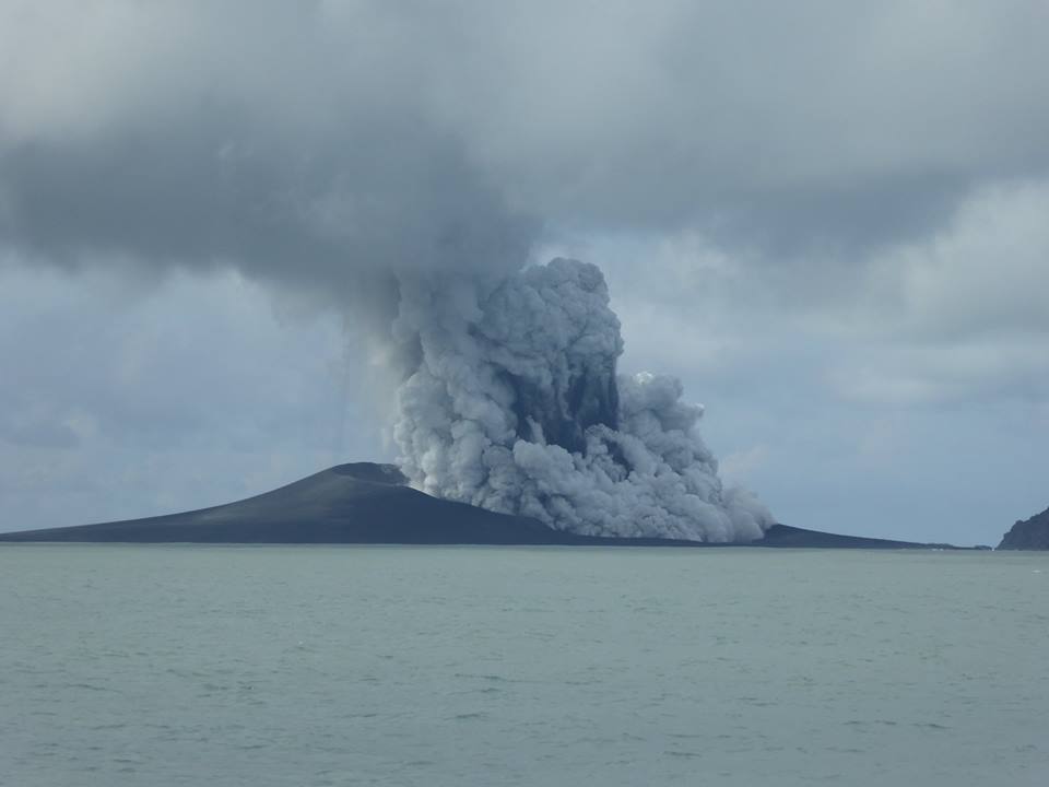
Hunga Tonga-Hunga Ha'apai, one of many submarine calderas NE of New Zealand in an island arc, has begun causing some problems for flights in the area. What started as a minor steam and ash eruption has now turned into a semi-major eruption in the area. Steam and ash clouds are reaching extraordinary heights, and the ongoing eruption is rapidly building a new island.


Photo from Volcano-discovery.com


Residents have reported that the eruption plume was changing hourly from white steam, to black ash clouds, in what was probably the ebb and flow of the tides covering the vent and interacting with hot lava. The eruption has sustained itself for months now, with no signs of slowing, and has breached the surface in a Surtseyan eruption.

Other reports have come in about 'the sea turning blood red'. This is more than likely a red-algae bloom. Algae blooms are common when volcanic nutrients flood the ocean water. This recently occurred in Alaska, and Iceland.

Surtseyan eruptions start as under water eruptions, gradually breaching the surface, and creating an island. The term comes from the island of Surtsey in Iceland, which was created in an eruption during ht 1960's. This was the first such eruption of its kind clearly observed from start to finish. The Icelandic fire-god Surtr is the inspiration for the eruption type.

It is unknown if this island will remain as a permanent land body. Many volcanoes of this type create islands that are rapidly eroded by the sea in the years following the cessation of the eruption, however based on the pictures I've seen, the island looks every bit as solid as Surtsey, or Anak Krakatau. Anak Krakatau is probably a better comparison, as it was also a post-caldera cone, much like Hunga Tonga-Hunga Ha'apai is.


Monday, December 29, 2014

Super busy but will post again soon!

To my readers:

Thanks for staying tuned. I recently went through a large job change, and had some family emergencies to take care of, as well as the holidays. I will be resuming posts again shortly.

I have not updated blogs regarding Fogo, Bardarbunga, or the Nevada quake swarm because nothing really has changed, and things continue as they have been.

Fogo and Bardarbunga continue to erupt at this time with no signs of change. Fogo volcano has swallowed up more villages on the volcano floor, including some historic towns over 100 years old. Bardarbunga's lava field is now about 80+ sq km in area, and caldera subsidence slowly continues, although current data isn't available due to equipment loss and weather conditions for Iceland Met Office.

The Nevada quake swarm is still ongoing, and USGS is installing new equipment. Quakes of mag 1.0-4.7 have occurred.

If you're looking for some quick volcano updates for the week, the Smithsonian GVP is a great place for current info at their Weekly Report section.

I'll be back on 'the job' after New Years.

Have a great holiday season everyone!

-Matt