Monday, August 18, 2014

Rare Lava Lake At Shishaldin Volcano

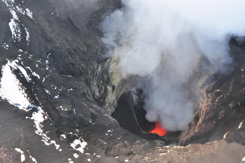
Alaska's Shishaldin volcano has apparently formed a lava lake deep within its summit crater, making it one out of only several active lava lakes on the planet. AVO's current update has the volcano remaining at aviation code 'orange', and eruptive activity has remained stable. AVO states:

"Low-level eruptive activity continues. Sound waves are currently being detected from the direction of Shishaldin on infrasound sensors located on Akutan Island. These signals are consistent with low-level activity at the volcano. No actvity (sp) has been detected in mostly cloudy Satellite images and web camera views are obscured by weather. No significant activity noted in seismic data."


Picture from AVO showing the small lava lake within Shishaldin's summit crater. (Credit Cyrus Read)

Shishaldin volcano is one of Alaska's most active volcanoes. A beautifully symmetrical volcano on Alaska's Unimak Island, far from any human population. The mian danger from this volcano could be unexpected ash emission, which would potentially be harmful to aircraft. However, the presence of a stable lava lake makes this rather unlikely, as gas is easily vented at this time, so large explosions are a bit less likely than say, if a lava dome was forming. In any case, keep your eyes on AVO for future updates and more great photographs. I'll post another update if anything changes. 


Tuesday, July 22, 2014

New Round Of Warnings For Mt Fuji

Apparently the news media wants to remind you of the dangers posed by Mt Fuji, who's magma chamber has been pressurized to unprecedented levels following 2011's major 9.0 earthquake in Japan. A 6.4, and 5.0 quake followed, centered under Mt Fuji, which has caused some concern for scientists and nearby cities. I reported on this over two years ago, and while not much has changed, it seems that this is back in the headlines again, so I thought I'd set the record straight, lest the news media sends you into a panic.


Mt Fuji seen from Japan.


Here are some basic facts.

Yes, Fuji is under an immense, even record amount, of pressure in its magma chamber. The pressure is currently greater than it was during the 1707 eruption which blasted a massive crater in the SE flank of the mountain. This means that any further disturbances, such as medium to large quakes in the region could fracture rock, and allow for magma and gas to rise, raising the risk of a highly explosive eruption.

This is by no means imminent, as it is impossible to predict quake activity or location. It simply means that Fuji is primed, and large quakes close to the mountain would increase this risk. Right now, no seismicity other than normal background rumblings are occurring. So there is no need at this time to panic.

Japan has been criticized for its lack of disaster planning regarding Fuji, however last year they did release a new evacuation plan in the event of an eruption, which would likely give some warning in the form of increased tremor (long period quakes, rock fracture tremors, etc) and increased gas emissions.

The important thing for scientists, and Japanese residents is to simply remain aware and vigilant of the threat. Japan is still recovering from the aftermath  of the 2011 quake, tsunami, and nuclear meltdown of the Fukushima Daiichi power plant which was damaged by the quake. A massive volcanic eruption from Fuji IS in the future for Japan, it is only a matter of time. That time however is impossible to know. Fuji is capable of depositing significant amounts of ash as far away as Tokyo, so an eruption would have severe consequences for an island already stressed by other disasters.

But again, this is nothing new, and we have known that Fuji is primed for several years now. As I can attest looking at my traffic charts on my own blog, any news about Fuji, one of the worlds most famous volcanoes, is always a click-generator. It doesn't mean you shouldn't pay attention, but don't lose too much sleep over it.

Friday, July 11, 2014

Outburst Flooding From Katla Volcano Iceland [UPDATED 7/16/14]

It appears that Katla Volcano in Iceland, under the Myrdalsjökull ice glacier is experiencing heightened activity. Fellow volcano blogger Jon Frimann has posted that Iceland has raised the alert level to 'uncertain', as glacial outburst floods or 'jökulhlaups' have been occurring, in conjunction with rising conductivity levels in rivers, as well as gaseous hazards being reported.

Katla volcano had a minor eruption following the now-famous eruption of Eyjafjallajökull in 2010.

Current seismicity is concentrated within the Katla caldera underneath the glacier, and no eruptive activity on the surface is yet apparent.

It is too soon to say whether any activity will increase. Other areas in Iceland are showing increased seismicity, including the Askja system, and the Torafjökull volcanic system, however no eruptions have occurred in Iceland since mid 2011 when the last eruption of Grimsnes (Grimsvötn) occurred.

If any updates happen, I'll update this post.

*****UPDATE 7/16/14*****

A larger quake swarm is occurring within the Katla caldera. The largest quake, which occurred yesterday, was magnitude 3.1. While numerous, these small quakes do not represent anything truly immense at this point. It is possible that eruptions might begin at the volcano, but these would likely be small, and probably not energetic enough to break free of the glacier.


(Click to enlarge) Image from en.vedur.is/Iceland Meterological Office showing quake swarm in Katla caldera.


Iceland has lifted the 'uncertain' warning from Katla, however it is possible for jökulhlaups (glacier outburst floods) to occur with little warning. Given the activity, I'd steer clear of the volcano and associated watersheds until things calm down. Hazards include jökulhlaups, gases, and the possibility of explosive eruption (even if unlikely at this point).

I'm keeping my eye on this one for a while. Iceland has had a few years of relative calm (by relative, I mean nothing too explosive... the land there is always seething), which is always a little nervous. Iceland's many volcanoes are always a potential threat, and can erupt with little, or very subtle warning.

Thursday, July 10, 2014

Large Quake Swarm at Long Valley Caldera, CA

After a few months of relative quiet at California's Long Valley Caldera, East of Mammoth Mountain volcano, activity has intensified with hundreds of small and shallow quakes at depths of around 4.7 miles. Many small tremors are occurring below the surface about 1.5 miles north of Yosemite Mammoth Airport. These are small quakes, and likely not able to be felt by anyone not at the epicenters. These quakes are interesting mostly due to the sheer numbers, not the magnitude.

More than likely these are hydrothermal 'spasmodic' quakes, related to liquid movement under the surface, and likely not a result of any serious magma intrusion. If there were a large intrusion of magma, you would expect to see the depths of the quakes change (these are all relatively consistent) to progressively shallower depths. Since this isn't occurring, it is reasonable to assume this is simply normal behavior for Long Valley's large hydrothermal system, rivaled only by Yellowstone in the US.


Image from Google Earth with USGS overlay detailing locations of quakes in Long Valley.

The Long Valley caldera is a so-called 'supervolcano', like Yellowstone, or the Valles Caldera in Mew Mexico. Long Valley was the source of one of the largest eruptions on Earth, approximately 760,000 years ago, which created the voluminous Bishop Tuff, a layer of ash and debris that spans most of the continental US. Like Yellowstone, Long Valley is capable of 'nation ending' eruptions, however this, like Yellowstone, would be extremely unlikely in our lifetimes. 

The last 'serious' activity at Long Valley was a 6.0+ mag quake in the late 70's, which was followed by rapid 'doming' in the center of the caldera. On average this 'resurgent doming' has added several centimeters in height per decade.

It is likely in the future that activity will resume at Long Valley, given the doming, active geothermal system, and persistent seismicity. For now, I wouldn't lose any sleep over this, as it is not only quite common, but completely normal activity. If larger quakes were to 'swarm' in the area, this would be a cause for concern.

*****UPDATE 7/11/14*****

Looks like the swarm is over for now. 

Wednesday, June 18, 2014

Is Mauna Loa Rumbling Back To Life?

Recent quake activity within the Mauna Loa volcanic system on the Big Island of Hawaii has some scientists and spectators wondering if Mauna Loa could be gearing up for another eruption in the near future. Many small quakes have been recorded under the summit and rift system lately, however this does not mean an eruption is imminent. While gradual inflation of the volcano has been occurring since 2010, the volcano is not displaying any signs typical of the volcano gearing up for an eruption, such as drastic inflation, changes in fumerole temperature, or large, rock-fracture quakes associated with magma rising through the crust.

But that really could change at any moment...

The main thing that would prevent an eruption of Mauna Loa is the fact that Kilauea is still highly active, and venting lava every day. This releases some pressure on the magma chamber of Mauna Loa, but deep down, the volcanoes are in fact linked at the magma source. If the magma plume exceeds what Kilauea pumps out, which is probably what's occurring slowly, Mauna Loa would experience refilling of its massive magma chamber, and slowly prime for an eruption.

Mauna Loa is one of Hawaii's most active volcanoes aside from Kilauea and Hualei (which last erupted in 1801), having last erupted in 1984 simultaneously with Kilauea who's 1983 eruption is still ongoing to this day. Typically Mauna Loa has erupted every several decades, and some volcanologist are of the mind that it is 'overdue' for an eruption - however volcanoes are never on a 'schedule', and statistical data for their eruptive periods is nearly useless.

There is no telling when Mauna Loa might actually erupt. Despite many efforts by the scientific community to accurately forecast volcanic eruptions months, or even years in advance, the technology and methodology simply has not coalesced yet. While it is easy to warn of an imminent eruption for most volcanoes a few hours before the activity increases (or at the very least, raise alert levels on restless volcanoes), forecasting an eruption from a volcano like Mauna Loa, which is one of the best studied volcanoes in the world, is still decades away at best.

HVO for now is keeping it's head cool and issued the most recent report on Mauna Loa:

"MAUNA LOA VOLCANO
(VNUM #332020)  19°28'30" N 155°36'29" W, Summit Elevation 13681 ft (4170 m)
Current Volcano Alert Level: NORMAL
Current Aviation Color Code: GREEN

No significant changes were recorded through May 2014.  Seismicity: Seismicity continued to be elevated over the average rates of the past 25 years-12 shallow events below summit area, 7 events to the west of Moku`āweoweo Crater (<13 km), 5 events to the north of Moku`āweoweo Crater, 17 shallow events on the Upper Southwest Rift (Sulfur Cone), 2 shallow events on the Lower Southwest Rift, 2 shallow events on the NE Rift Zone.  

Deformation: GPS and tilt networks did not record any changes in deformation rates or patterns that were significantly above the error of the measurements during May. Southeasterly motion of the south flank continued.  Gas: No significant changes in SO2, CO2 were recorded by the Mokuaweoweo gas and temperature monitors in May. Daily average fumarole temperature during the month declined from 76 to 75 degrees C, still not back down though to the 71.7 degrees average of several months ago.  

Background: Re-inflation of Mauna Loa's shallow magma storage reservoirs started immediately following the most recent eruption in 1984, then turned to deflation for almost a decade. In mid-2002, inflation started again, just after a brief swarm of deep long-period (LP) earthquakes. A more intense swarm of several thousand deep Long Period (LP) earthquakes occurred in late 2004, immediately preceding a dramatic increase in inflation rate. Inflation slowed again in 2006, ceased altogether in late 2009, and resumed slowly in late 2010.  Rising gradually to more than 4 km above sea level, Mauna Loa is the largest active volcano on our planet. Its long submarine flanks descend to the sea floor an additional 5 km, and the sea floor in turn is depressed by Mauna Loa's great mass another 8 km. This makes the volcano's summit about 17 km (56,000 ft) above its base!

The enormous volcano covers half of the Island of Hawai`i and by itself amounts to about 85 percent of all the other Hawaiian Islands combined.  Mauna Loa is the largest active volcano on Earth and is among Earth's most active volcanoes, having erupted 33 times since its first well-documented historical eruption in 1843. Its most recent eruption was in 1984. Fore more information on Mauna Loa, see the USGS Fact sheet available at http://pubs.usgs.gov/fs/2012/3104/fs2012-3104.pdf.   CONTACT INFORMATION: askHVO@usgs.gov  The Hawaiian Volcano Observatory is one of five volcano observatories within the U.S. Geological Survey and is responsible for monitoring volcanoes and earthquakes in Hawai`i."