
Wow! In the several years I have been covering volcanic eruptions, I have never once seen AVO raise a volcano to RED Alert, but this occurred yesterday as Pavlof Volcano, which has experienced unrest beginning May 31st was raised to the highest alert level. Massive explosions are now taking place. According to AVO on May 31st:

"Elevated surface temperatures were detected at the summit of Pavlof volcano in satellite imagery this morning suggesting that the volcano is experiencing a low-level eruption with lava at the surface. A low level steam plume is visible in satellite imagery and in the FAA web camera located in Cold Bay. A pilot reported a gas and ash plume drifting north at 7,000 to 8,000 feet above sea level. Based on these observations AVO is raising the Aviation Color Code to ORANGE and the Volcano Alert Level to WATCH for Pavlof volcano."
And suddenly, yesterday, the alert was raised to RED:
"The low-level eruption of Pavlof has escalated. Seismic tremor increased starting about 2300 UTC today and pilots have recently reported ash clouds to 22,000 ft. ASL. Recent satellite images show a plume extending over 80 km east of the volcano."
The alert level of Red will mean that flights will have to divert, as the ash plume is quite large. No populations are at risk for this eruption, as it is in a very remote part of Alaska, however there is a small airstrip east of the volcano at the foot of another volcano, Dutton (which is currently inactive), and an associated port town named King Cove, with an estimated population of around 792 (according to the 2000 census, which is probably a wee bit out of date). It is possible this area will experience fine ashfall, which does carry risks of its own.
Another town that could potentially experience ashfall would be Cold Bay, which is around 15km NE of Cold Bay Volcano (which is either dormant or extinct), and approximately 60km ESE of Pavlof.
Unfortunately for eruption fans, there is no web cam pointed at the eruption. This could potentially change if the eruption continues and AVO sends out a team, but given weather, budget constraints, and the danger of Alaskan travel, this might be unlikely.
This eruption marks the largest in years, and will likely be of great scientific interest. It will be a pain for air travel, however, and there is no telling how long the eruption may last. The last eruption of Pavlof was in may 2013. Pavlof is one of Alaskas most active stratovolcanoes, with numerous historical eruptions. Some eruptions have been highly explosive, like this ones, and others have consisted of effusive fissure eruptions.

AVO has lowered the alert level back down to Orange due to a decrease in eruptive activity.

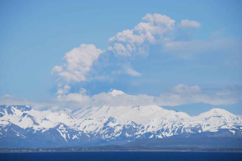
Image from June 2, 2014 from AVO, Eruption of Pavlof Volcano. Image copyright Christopher Diaz at northernXposed Photography.
"Elevated surface temperatures were detected at the summit of Pavlof volcano in satellite imagery this morning suggesting that the volcano is experiencing a low-level eruption with lava at the surface. A low level steam plume is visible in satellite imagery and in the FAA web camera located in Cold Bay. A pilot reported a gas and ash plume drifting north at 7,000 to 8,000 feet above sea level. Based on these observations AVO is raising the Aviation Color Code to ORANGE and the Volcano Alert Level to WATCH for Pavlof volcano."
And suddenly, yesterday, the alert was raised to RED:
"The low-level eruption of Pavlof has escalated. Seismic tremor increased starting about 2300 UTC today and pilots have recently reported ash clouds to 22,000 ft. ASL. Recent satellite images show a plume extending over 80 km east of the volcano."
The alert level of Red will mean that flights will have to divert, as the ash plume is quite large. No populations are at risk for this eruption, as it is in a very remote part of Alaska, however there is a small airstrip east of the volcano at the foot of another volcano, Dutton (which is currently inactive), and an associated port town named King Cove, with an estimated population of around 792 (according to the 2000 census, which is probably a wee bit out of date). It is possible this area will experience fine ashfall, which does carry risks of its own.
Another town that could potentially experience ashfall would be Cold Bay, which is around 15km NE of Cold Bay Volcano (which is either dormant or extinct), and approximately 60km ESE of Pavlof.
Unfortunately for eruption fans, there is no web cam pointed at the eruption. This could potentially change if the eruption continues and AVO sends out a team, but given weather, budget constraints, and the danger of Alaskan travel, this might be unlikely.
This eruption marks the largest in years, and will likely be of great scientific interest. It will be a pain for air travel, however, and there is no telling how long the eruption may last. The last eruption of Pavlof was in may 2013. Pavlof is one of Alaskas most active stratovolcanoes, with numerous historical eruptions. Some eruptions have been highly explosive, like this ones, and others have consisted of effusive fissure eruptions.

Eruption of Pavlof (Photo from Smithsonian GVP) in 1996.
A red alert is defined by AVO: "RED: Eruption is imminent with significant emission of volcanic ash into the atmosphere likely OR eruption is underway or suspected with significant emission of volcanic ash into the atmosphere [ash-plume height specified, if possible]." Eruptions of this magnitude can have far-reaching effects as ash and gas circles the globe, as seen during the 2010 eruption of Iceland's Eyjafjallajökull volcano, which grounded air travel over most of Europe, and stranded many travelers, not to mention, making a headache for Iceland residents caught in the ash clouds.
This brings the total number of Alaskan volcanoes experiencing heightened activity to four; Shishaldin, Veniaminof, Cleveland, and Pavlof.
If any significant changes occur, I will update this post.
*****UPDATE*****
AVO has lowered the alert level back down to Orange due to a decrease in eruptive activity.
An FAA webcam yesterday recorded 'intense lava fountaining' from Pavlof. You can view the webcam here.
AVO released the following statements:
6/3 (still Red)
"The eruption of Pavlof Volcano continues. After elevation to Aviation Color Code RED yesterday late afternoon, seismic tremor began to decrease somewhat about 0800 UTC (11 pm AKDT) last night. Nighttime web camera images from Cold Bay showed intense lava fountaining at the summit and incandescence from the spatter-fed lava flow on the north flank. Seismic tremor increased again this morning and web camera images and pilot reports indicated the ash and steam plume up to 24,000 ft. ASL. Following an overnight shift in wind direction, the main plume is currently being carried south-southwest of the volcano. Lower-level winds (below 10,000 ft) extend west-southwest and may be carrying trace amounts of ash. There are no reports of ash falling in nearby communities."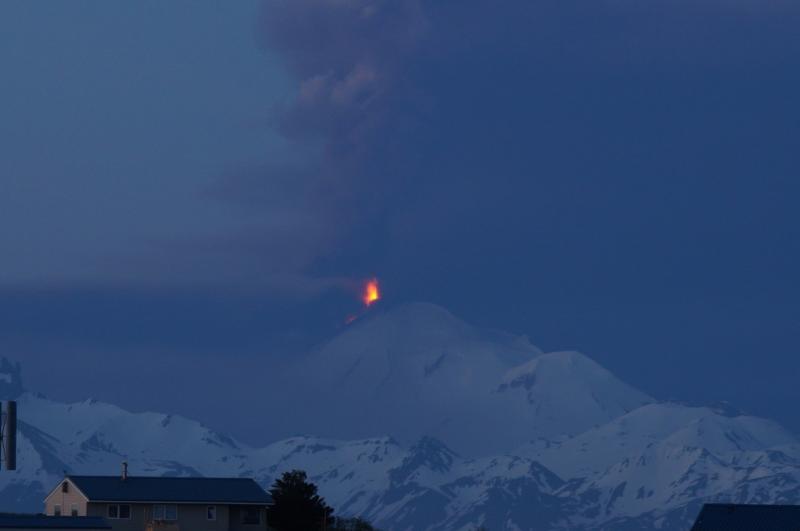
Photo from AVO, Pavlof eruption with lava fountaining, early June 3, 2014, as viewed from Cold Bay. Photo courtesy of Robert Stacy.
6/4 (lowered to Orange)
"AVO is reducing the Aviation Color Code to ORANGE and the Volcano Alert Level to WATCH for Pavlof Volcano. Although the eruption of Pavlof continues, seismic tremor has deceased over the past 12 hours and has remained relatively steady throughout the day at a much lower level than that of yesterday. Recent satellite data and web camera views of the eruption plume indicate that there are now two distinct parts of the plume. The part of the plume that reaches high above the volcano appears to be mainly steam and gas with minor ash present, extending south of the volcano. Additionally, pyroclastic flow activity on the north flank is producing diffuse ash emissions that result in areas of hazy air, with variable concentrations of ash below 10,000 ft. Low-level winds are likely to disperse this ash to the west-southwest with no more than trace amounts accumulating. There are no reports of ash falling in nearby communities. Hazardous conditions exist on the north flank and north side drainages heading on the volcano due to continued pyroclastic and lahar activity. Ash in the vicinity of the volcano remains a hazard to local air traffic. AVO will continue to closely monitor the activity at Pavlof. With the eruption ongoing, conditions can change rapidly, and the possibility remains for large, more ash-rish (sic) plumes to develop with little or no warning."


